Ipil geodata
Ipil (Mimaropa) is a populated place; located in Philippines in Asia/Manila (GMT+8) time zone. With population of 2,468 people, there are 3349 cities with bigger population in this country. Compared to other cities in Philippines, 62.3% of cities are located further ↓South; 60.4% of cities are located further →East and 68.5% of cities have lower elevation than Ipil. Note1


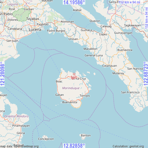
Ipil GPS coordinates[2]
13° 30' 47.52" North, 121° 59' 2.76" East
| Map corner | latitude | longitude |
|---|---|---|
| Upper-left | 14.19586°, | 121.28098° |
| Center: | 13.5132°, | 121.9841° |
| Lower-right: | 12.82858°, | 122.68723° |
| Map W x H: | 152×152 km | = 94.4×94.4mi |
| max Lat: | 20.78733° ⇑37.7% North |
| Ipil: | 13.5132° |
| min Lat: | ⇓62.3% South 4.65442° |
| min Long | Ipil | max Long |
| 117.04868° | 121.9841° | 126.58417° |
| W 39.6%⇐ | ⇒60.4% E |
Elevation
Elevation of Ipil is 49 m = 161 ft, and this is 38.9 m = 128 ft below average elevation for this country.
| Max E: |
2262 m = 7421 ft | 31.5% |
| Avg. | 87.9 m = 288 ft | |
| Ipil | 49 m = 161 ft | |
Min E: |
-2 m = -7 ft | 68.5% |
See also: Philippines elevation on elevation.city.
Geographical zone
Ipil is located in North Torrid zone (between Equator and Tropic of Cancer). Distance of this Northern Tropic circle is 1103.4 km =685.6 mi to North.| Distance of | km | miles | from Ipil |
|---|---|---|---|
| North Pole | 8504.5 | 5284.4 | to North |
| Arctic Circle | 5898.6 | 3665.2 | to North |
| Tropic Cancer | 1103.4 | 685.6 | to North |
| Equator | 1502.5 | 933.6 | to South |


Nearby cities:
15 places around Ipil: (largest is in red/bold)
• Balanacan
12.7 km =7.9 mi,  277°
277°
• Barangay of Poblacion
24.1 km =15 mi,  154°
154°
• Bintacay
11.7 km =7.3 mi,  262°
262°
• Boac
17.3 km =10.7 mi,  244°
244°
• Buyabod
9 km =5.6 mi,  124°
124°
• Gasan
25.8 km =16 mi,  215°
215°
• General Luna
27.9 km =17.3 mi,  46°
46°
• Laylay
19.5 km =12.1 mi,  245°
245°
• Malibago
26.5 km =16.5 mi,  170°
170°
• Masiga
23.9 km =14.9 mi, 224°
• Mogpog
13.9 km =8.6 mi, 252°
• Santa Cruz
6.3 km =3.9 mi,  131°
131°
• Tiguion
23.9 km =14.9 mi,  213°
213°
• Torrijos
24.3 km =15.1 mi, 154°
• Tuhian
28 km =17.4 mi,  64°
64°
Sources, notices
• [Note1] Compared only with cities in Philippines existing in our database
• [Src1] Map data: © OpenStreetMap contributors (CC-BY-SA)
• [Src2] Other city data from geonames.org with taken over terms of usage.
• [Src3] Geographical zone / Annual Mean Temperature by Robert A. Rohde @ Wikipedia
