San Pedro geodata
San Pedro (Cagayan Valley) is a populated place; located in Philippines in Asia/Manila (GMT+8) time zone. With population of 3,027 people, there are 2493 cities with bigger population in this country. Compared to other cities in Philippines, 94.7% of cities are located further ↓South; 61.7% of cities are located further →East and 60.3% of cities have lower elevation than San Pedro. Note1
Administrative division(s):
- Level 1: Cagayan Valley
- Level 2: Province of Isabela
- Level 3: Ilagan City


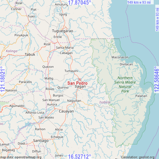
San Pedro GPS coordinates[2]
17° 12' 0" North, 121° 52' 59.988" East
| Map corner | latitude | longitude |
|---|---|---|
| Upper-left | 17.87045°, | 121.18021° |
| Center: | 17.2°, | 121.88333° |
| Lower-right: | 16.52712°, | 122.58646° |
| Map W x H: | 149.4×149.4 km | = 92.8×92.8mi |
| max Lat: | 20.78733° ⇑5.3% North |
| San Pedro: | 17.2° |
| min Lat: | ⇓94.7% South 4.65442° |
| min Long | San Pedro | max Long |
| 117.04868° | 121.88333° | 126.58417° |
| W 38.3%⇐ | ⇒61.7% E |
Elevation
Elevation of San Pedro is 34 m = 112 ft, and this is 53.9 m = 177 ft below average elevation for this country.
| Max E: |
2262 m = 7421 ft | 39.7% |
| Avg. | 87.9 m = 288 ft | |
| San Pedro | 34 m = 112 ft | |
Min E: |
-2 m = -7 ft | 60.3% |
See also: Philippines elevation on elevation.city.
Geographical zone
San Pedro is located in North Torrid zone (between Equator and Tropic of Cancer). Distance of this Northern Tropic circle is 693.5 km =430.9 mi to North.| Distance of | km | miles | from San Pedro |
|---|---|---|---|
| North Pole | 8094.6 | 5029.7 | to North |
| Arctic Circle | 5488.7 | 3410.5 | to North |
| Tropic Cancer | 693.5 | 430.9 | to North |
| Equator | 1912.5 | 1188.4 | to South |


Nearby cities:
15 places around San Pedro: (largest is in red/bold)
• Alibago
9.4 km =5.8 mi,  190°
190°
• Antagan Segunda
9.3 km =5.8 mi,  352°
352°
• Cabannungan Second
9 km =5.6 mi,  202°
202°
• Gamu
17.4 km =10.8 mi, 196°
• Ganapi
1.9 km =1.2 mi,  275°
275°
• Ilagan
5.8 km =3.6 mi,  173°
173°
• Magsaysay
16.5 km =10.3 mi,  316°
316°
• Manaring
3.6 km =2.2 mi,  145°
145°
• Ragan Norte
17.9 km =11.1 mi, 319°
• San Antonio
12.7 km =7.9 mi,  309°
309°
• San Mateo
16.2 km =10.1 mi,  244°
244°
• Santo Domingo
14.7 km =9.1 mi,  252°
252°
• Tumauini
11.6 km =7.2 mi, 317°
• Ugad
14.8 km =9.2 mi, 323°
• Upi
14 km =8.7 mi, 201°
Sources, notices
• [Note1] Compared only with cities in Philippines existing in our database
• [Src1] Map data: © OpenStreetMap contributors (CC-BY-SA)
• [Src2] Other city data from geonames.org with taken over terms of usage.
• [Src3] Geographical zone / Annual Mean Temperature by Robert A. Rohde @ Wikipedia
