San Antonio geodata
San Antonio (Cagayan Valley) is a populated place; located in Philippines in Asia/Manila (GMT+8) time zone. With population of 2,810 people, there are 2779 cities with bigger population in this country. Compared to other cities in Philippines, 95% of cities are located further ↓South; 62.7% of cities are located further →East and 64.1% of cities have lower elevation than San Antonio. Note1
Administrative division(s):
- Level 1: Cagayan Valley
- Level 2: Province of Isabela
- Level 3: Delfin Albano (Magsaysay)


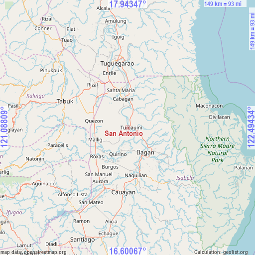
San Antonio GPS coordinates[2]
17° 16' 23.844" North, 121° 47' 28.356" East
| Map corner | latitude | longitude |
|---|---|---|
| Upper-left | 17.94347°, | 121.08809° |
| Center: | 17.27329°, | 121.79121° |
| Lower-right: | 16.60067°, | 122.49434° |
| Map W x H: | 149.3×149.3 km | = 92.8×92.8mi |
| max Lat: | 20.78733° ⇑5% North |
| San Antonio: | 17.27329° |
| min Lat: | ⇓95% South 4.65442° |
| min Long | San Antonio | max Long |
| 117.04868° | 121.79121° | 126.58417° |
| W 37.3%⇐ | ⇒62.7% E |
Elevation
Elevation of San Antonio is 40 m = 131 ft, and this is 47.9 m = 157 ft below average elevation for this country.
| Max E: |
2262 m = 7421 ft | 35.9% |
| Avg. | 87.9 m = 288 ft | |
| San Antonio | 40 m = 131 ft | |
Min E: |
-2 m = -7 ft | 64.1% |
See also: Philippines elevation on elevation.city.
Geographical zone
San Antonio is located in North Torrid zone (between Equator and Tropic of Cancer). Distance of this Northern Tropic circle is 685.3 km =425.8 mi to North.| Distance of | km | miles | from San Antonio |
|---|---|---|---|
| North Pole | 8086.5 | 5024.7 | to North |
| Arctic Circle | 5480.6 | 3405.5 | to North |
| Tropic Cancer | 685.3 | 425.8 | to North |
| Equator | 1920.6 | 1193.4 | to South |


Nearby cities:
15 places around San Antonio: (largest is in red/bold)
• Antagan Segunda
8.6 km =5.3 mi,  83°
83°
• Bulu
7.2 km =4.5 mi,  338°
338°
• Calinaoan Malasin
10.3 km =6.4 mi,  328°
328°
• Ganapi
11.2 km =7 mi,  135°
135°
• Magsaysay
4.1 km =2.5 mi, 339°
• Masipi West
12.8 km =8 mi,  23°
23°
• Pilig
7.9 km =4.9 mi,  346°
346°
• Ragan Norte
5.8 km =3.6 mi, 342°
• San Bernardo
15.2 km =9.4 mi, 343°
• San Juan
15.4 km =9.6 mi, 342°
• San Pedro
12.7 km =7.9 mi,  129°
129°
• Santo Domingo
13.3 km =8.3 mi,  198°
198°
• Santo Tomas
14.3 km =8.9 mi, 348°
• Tumauini
1.9 km =1.2 mi, 78°
• Ugad
3.9 km =2.4 mi,  14°
14°
Sources, notices
• [Note1] Compared only with cities in Philippines existing in our database
• [Src1] Map data: © OpenStreetMap contributors (CC-BY-SA)
• [Src2] Other city data from geonames.org with taken over terms of usage.
• [Src3] Geographical zone / Annual Mean Temperature by Robert A. Rohde @ Wikipedia
