Agusan geodata
Agusan (Northern Mindanao) is a populated place; located in Philippines in Asia/Manila (GMT+8) time zone. With population of 14,756 people, there are 454 cities with bigger population in this country. Compared to other cities in Philippines, 78.8% of cities are located further ↑North; 83% of cities are located further ←West and 100% of cities have higher elevation than Agusan. Note1


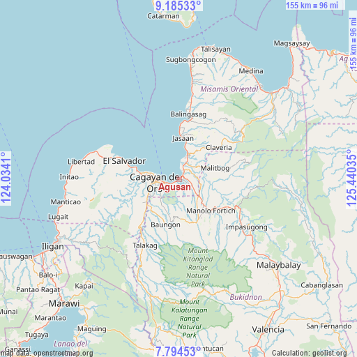
Agusan GPS coordinates[2]
8° 29' 26.016" North, 124° 44' 13.992" East
| Map corner | latitude | longitude |
|---|---|---|
| Upper-left | 9.18533°, | 124.0341° |
| Center: | 8.49056°, | 124.73722° |
| Lower-right: | 7.79453°, | 125.44035° |
| Map W x H: | 154.6×154.6 km | = 96.1×96.1mi |
| max Lat: | 20.78733° ⇑78.8% North |
| Agusan: | 8.49056° |
| min Lat: | ⇓21.2% South 4.65442° |
| min Long | Agusan | max Long |
| 117.04868° | 124.73722° | 126.58417° |
| W 83%⇐ | ⇒17% E |
Elevation
Elevation of Agusan is 0 m = 0 ft, and this is 87.9 m = 288 ft below average elevation for this country.
| Max E: |
2262 m = 7421 ft | 100% |
| Avg. | 87.9 m = 288 ft | |
| Agusan | 0 m = 0 ft | |
Min E: |
-2 m = -7 ft | 0% |
See also: Philippines elevation on elevation.city.
Geographical zone
Agusan is located in North Torrid zone (between Equator and Tropic of Cancer). Distance of Equator is 944.1 km =586.6 mi to South.| Distance of | km | miles | from Agusan |
|---|---|---|---|
| North Pole | 9063 | 5631.5 | to North |
| Arctic Circle | 6457.1 | 4012.3 | to North |
| Tropic Cancer | 1661.9 | 1032.7 | to North |
| Equator | 944.1 | 586.6 | to South |


Nearby cities:
15 places around Agusan: (largest is in red/bold)
• Alae
11.1 km =6.9 mi,  131°
131°
• Aplaya
13.6 km =8.5 mi,  14°
14°
• Barra
14.8 km =9.2 mi,  278°
278°
• Bugo
3.1 km =1.9 mi,  51°
51°
• Cagayan de Oro
9.9 km =6.2 mi,  264°
264°
• Igpit
16.7 km =10.4 mi, 277°
• Kimaya
14 km =8.7 mi, 53°
• Libona
16.9 km =10.5 mi,  180°
180°
• Malitbog
16.7 km =10.4 mi,  73°
73°
• Mambatangan
12.3 km =7.6 mi,  121°
121°
• San Martin
8.7 km =5.4 mi,  25°
25°
• Santa Ana
5.8 km =3.6 mi,  60°
60°
• Solana
15.2 km =9.4 mi, 13°
• Tagoloan
5.8 km =3.6 mi,  18°
18°
• Villanueva
11.7 km =7.3 mi, 21°
Sources, notices
• [Note1] Compared only with cities in Philippines existing in our database
• [Src1] Map data: © OpenStreetMap contributors (CC-BY-SA)
• [Src2] Other city data from geonames.org with taken over terms of usage.
• [Src3] Geographical zone / Annual Mean Temperature by Robert A. Rohde @ Wikipedia
