San Juan geodata
San Juan (Cagayan Valley) is a populated place; located in Philippines in Asia/Manila (GMT+8) time zone. With population of 2,517 people, there are 3258 cities with bigger population in this country. Compared to other cities in Philippines, 95.6% of cities are located further ↓South; 63.3% of cities are located further →East and 60.3% of cities have lower elevation than San Juan. Note1


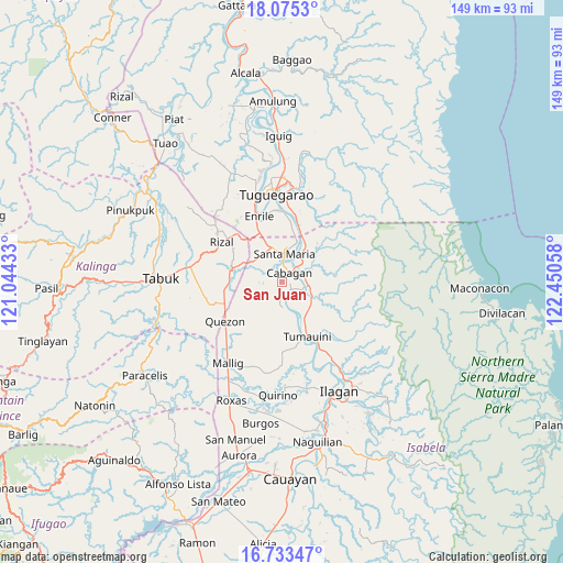
San Juan GPS coordinates[2]
17° 24' 20.232" North, 121° 44' 50.82" East
| Map corner | latitude | longitude |
|---|---|---|
| Upper-left | 18.0753°, | 121.04433° |
| Center: | 17.40562°, | 121.74745° |
| Lower-right: | 16.73347°, | 122.45058° |
| Map W x H: | 149.2×149.2 km | = 92.7×92.7mi |
| max Lat: | 20.78733° ⇑4.4% North |
| San Juan: | 17.40562° |
| min Lat: | ⇓95.6% South 4.65442° |
| min Long | San Juan | max Long |
| 117.04868° | 121.74745° | 126.58417° |
| W 36.7%⇐ | ⇒63.3% E |
Elevation
Elevation of San Juan is 34 m = 112 ft, and this is 53.9 m = 177 ft below average elevation for this country.
| Max E: |
2262 m = 7421 ft | 39.7% |
| Avg. | 87.9 m = 288 ft | |
| San Juan | 34 m = 112 ft | |
Min E: |
-2 m = -7 ft | 60.3% |
See also: Philippines elevation on elevation.city.
Geographical zone
San Juan is located in North Torrid zone (between Equator and Tropic of Cancer). Distance of this Northern Tropic circle is 670.6 km =416.7 mi to North.| Distance of | km | miles | from San Juan |
|---|---|---|---|
| North Pole | 8071.7 | 5015.5 | to North |
| Arctic Circle | 5465.9 | 3396.4 | to North |
| Tropic Cancer | 670.6 | 416.7 | to North |
| Equator | 1935.3 | 1202.5 | to South |


Nearby cities:
15 places around San Juan: (largest is in red/bold)
• Bangad
10.5 km =6.5 mi,  17°
17°
• Binguang
7.8 km =4.8 mi,  40°
40°
• Bulu
8.3 km =5.2 mi,  165°
165°
• Cabagan
3.4 km =2.1 mi, 43°
• Calamagui East
9.4 km =5.8 mi,  13°
13°
• Calinaoan Malasin
6 km =3.7 mi,  186°
186°
• Magsaysay
11.3 km =7 mi,  163°
163°
• Masipi West
10.1 km =6.3 mi,  106°
106°
• Minanga Norte
6.6 km =4.1 mi, 37°
• Mozzozzin Sur
5.7 km =3.5 mi,  358°
358°
• Pilig
7.5 km =4.7 mi, 158°
• Ragan Norte
9.6 km =6 mi, 162°
• San Bernardo
0.4 km =0.2 mi,  101°
101°
• Santa Maria
6.8 km =4.2 mi,  4°
4°
• Santo Tomas
1.9 km =1.2 mi, 109°
Sources, notices
• [Note1] Compared only with cities in Philippines existing in our database
• [Src1] Map data: © OpenStreetMap contributors (CC-BY-SA)
• [Src2] Other city data from geonames.org with taken over terms of usage.
• [Src3] Geographical zone / Annual Mean Temperature by Robert A. Rohde @ Wikipedia
