Cabagan geodata
Cabagan (Cagayan Valley) is a seat of a third-order administrative division; located in Philippines in Asia/Manila (GMT+8) time zone. With population of 25,304 people, there are 319 cities with bigger population in this country. Compared to other cities in Philippines, 95.7% of cities are located further ↓South; 63% of cities are located further →East and 57.4% of cities have lower elevation than Cabagan. Note1


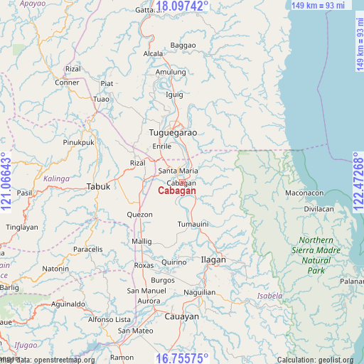
Cabagan GPS coordinates[2]
17° 25' 40.152" North, 121° 46' 10.38" East
| Map corner | latitude | longitude |
|---|---|---|
| Upper-left | 18.09742°, | 121.06643° |
| Center: | 17.42782°, | 121.76955° |
| Lower-right: | 16.75575°, | 122.47268° |
| Map W x H: | 149.2×149.2 km | = 92.7×92.7mi |
| max Lat: | 20.78733° ⇑4.3% North |
| Cabagan: | 17.42782° |
| min Lat: | ⇓95.7% South 4.65442° |
| min Long | Cabagan | max Long |
| 117.04868° | 121.76955° | 126.58417° |
| W 37%⇐ | ⇒63% E |
Elevation
Elevation of Cabagan is 30 m = 98 ft, and this is 57.9 m = 190 ft below average elevation for this country.
| Max E: |
2262 m = 7421 ft | 42.6% |
| Avg. | 87.9 m = 288 ft | |
| Cabagan | 30 m = 98 ft | |
Min E: |
-2 m = -7 ft | 57.4% |
See also: Philippines elevation on elevation.city.
Geographical zone
Cabagan is located in North Torrid zone (between Equator and Tropic of Cancer). Distance of this Northern Tropic circle is 668.1 km =415.1 mi to North.| Distance of | km | miles | from Cabagan |
|---|---|---|---|
| North Pole | 8069.3 | 5014 | to North |
| Arctic Circle | 5463.4 | 3394.8 | to North |
| Tropic Cancer | 668.1 | 415.1 | to North |
| Equator | 1937.8 | 1204.1 | to South |


Nearby cities:
15 places around Cabagan: (largest is in red/bold)
• Bangad
7.6 km =4.7 mi,  6°
6°
• Binguang
4.4 km =2.7 mi,  38°
38°
• Bulu
10.5 km =6.5 mi,  181°
181°
• Calamagui East
6.7 km =4.2 mi,  359°
359°
• Calinaoan Malasin
9 km =5.6 mi,  199°
199°
• Divisoria
10.6 km =6.6 mi,  2°
2°
• Masipi West
9.1 km =5.7 mi,  126°
126°
• Minanga Norte
3.2 km =2 mi,  31°
31°
• Mozzozzin Sur
4.1 km =2.5 mi,  322°
322°
• Pilig
9.5 km =5.9 mi, 177°
• San Bernardo
3.2 km =2 mi,  216°
216°
• San Juan
3.4 km =2.1 mi, 223°
• Santa Maria
4.7 km =2.9 mi,  336°
336°
• Santo Tomas
3.2 km =2 mi,  189°
189°
• Simanu Sur
9.4 km =5.8 mi,  47°
47°
Sources, notices
• [Note1] Compared only with cities in Philippines existing in our database
• [Src1] Map data: © OpenStreetMap contributors (CC-BY-SA)
• [Src2] Other city data from geonames.org with taken over terms of usage.
• [Src3] Geographical zone / Annual Mean Temperature by Robert A. Rohde @ Wikipedia
