Calamagui East geodata
Calamagui East (Cagayan Valley) is a populated place; located in Philippines in Asia/Manila (GMT+8) time zone. With population of 2,671 people, there are 2997 cities with bigger population in this country. Compared to other cities in Philippines, 96.1% of cities are located further ↓South; 63% of cities are located further →East and 58.1% of cities have lower elevation than Calamagui East. Note1
Administrative division(s):
- Level 1: Cagayan Valley
- Level 2: Province of Isabela
- Level 3: Santa Maria


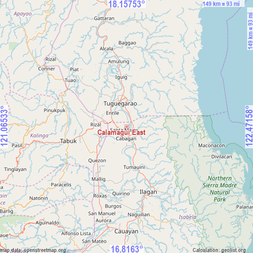
Calamagui East GPS coordinates[2]
17° 29' 17.34" North, 121° 46' 6.42" East
| Map corner | latitude | longitude |
|---|---|---|
| Upper-left | 18.15753°, | 121.06533° |
| Center: | 17.48815°, | 121.76845° |
| Lower-right: | 16.8163°, | 122.47158° |
| Map W x H: | 149.1×149.1 km | = 92.6×92.6mi |
| max Lat: | 20.78733° ⇑3.9% North |
| Calamagui East: | 17.48815° |
| min Lat: | ⇓96.1% South 4.65442° |
| min Long | Calamagui East | max Long |
| 117.04868° | 121.76845° | 126.58417° |
| W 37%⇐ | ⇒63% E |
Elevation
Elevation of Calamagui East is 31 m = 102 ft, and this is 56.9 m = 187 ft below average elevation for this country.
| Max E: |
2262 m = 7421 ft | 41.9% |
| Avg. | 87.9 m = 288 ft | |
| Calamagui East | 31 m = 102 ft | |
Min E: |
-2 m = -7 ft | 58.1% |
See also: Philippines elevation on elevation.city.
Geographical zone
Calamagui East is located in North Torrid zone (between Equator and Tropic of Cancer). Distance of this Northern Tropic circle is 661.4 km =411 mi to North.| Distance of | km | miles | from Calamagui East |
|---|---|---|---|
| North Pole | 8062.6 | 5009.9 | to North |
| Arctic Circle | 5456.7 | 3390.6 | to North |
| Tropic Cancer | 661.4 | 411 | to North |
| Equator | 1944.5 | 1208.3 | to South |


Nearby cities:
15 places around Calamagui East: (largest is in red/bold)
• Bangad
1.2 km =0.7 mi,  48°
48°
• Binguang
4.3 km =2.7 mi,  138°
138°
• Cabagan
6.7 km =4.2 mi,  179°
179°
• Divisoria
3.9 km =2.4 mi,  9°
9°
• Enrile
10.9 km =6.8 mi,  316°
316°
• Liwan
14.9 km =9.3 mi,  283°
283°
• Magalalag
10.5 km =6.5 mi,  340°
340°
• Masipi West
14.2 km =8.8 mi,  148°
148°
• Minanga Norte
4.4 km =2.7 mi,  155°
155°
• Mozzozzin Sur
4.2 km =2.6 mi,  214°
214°
• San Bernardo
9.4 km =5.8 mi,  190°
190°
• San Juan
9.4 km =5.8 mi, 193°
• Santa Maria
3 km =1.9 mi,  215°
215°
• Santo Tomas
9.8 km =6.1 mi, 182°
• Simanu Sur
7 km =4.3 mi,  92°
92°
Sources, notices
• [Note1] Compared only with cities in Philippines existing in our database
• [Src1] Map data: © OpenStreetMap contributors (CC-BY-SA)
• [Src2] Other city data from geonames.org with taken over terms of usage.
• [Src3] Geographical zone / Annual Mean Temperature by Robert A. Rohde @ Wikipedia
