Pilig geodata
Pilig (Cagayan Valley) is a populated place; located in Philippines in Asia/Manila (GMT+8) time zone. With population of 2,336 people, there are 3593 cities with bigger population in this country. Compared to other cities in Philippines, 95.3% of cities are located further ↓South; 62.9% of cities are located further →East and 60.3% of cities have lower elevation than Pilig. Note1


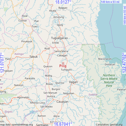
Pilig GPS coordinates[2]
17° 20' 34.008" North, 121° 46' 26.004" East
| Map corner | latitude | longitude |
|---|---|---|
| Upper-left | 18.0127°, | 121.07077° |
| Center: | 17.34278°, | 121.77389° |
| Lower-right: | 16.67041°, | 122.47702° |
| Map W x H: | 149.2×149.3 km | = 92.7×92.8mi |
| max Lat: | 20.78733° ⇑4.7% North |
| Pilig: | 17.34278° |
| min Lat: | ⇓95.3% South 4.65442° |
| min Long | Pilig | max Long |
| 117.04868° | 121.77389° | 126.58417° |
| W 37.1%⇐ | ⇒62.9% E |
Elevation
Elevation of Pilig is 34 m = 112 ft, and this is 53.9 m = 177 ft below average elevation for this country.
| Max E: |
2262 m = 7421 ft | 39.7% |
| Avg. | 87.9 m = 288 ft | |
| Pilig | 34 m = 112 ft | |
Min E: |
-2 m = -7 ft | 60.3% |
See also: Philippines elevation on elevation.city.
Geographical zone
Pilig is located in North Torrid zone (between Equator and Tropic of Cancer). Distance of this Northern Tropic circle is 677.6 km =421 mi to North.| Distance of | km | miles | from Pilig |
|---|---|---|---|
| North Pole | 8078.7 | 5019.9 | to North |
| Arctic Circle | 5472.8 | 3400.6 | to North |
| Tropic Cancer | 677.6 | 421 | to North |
| Equator | 1928.3 | 1198.2 | to South |


Nearby cities:
15 places around Pilig: (largest is in red/bold)
• Antagan Segunda
12.3 km =7.6 mi,  122°
122°
• Bulu
1.3 km =0.8 mi,  216°
216°
• Cabagan
9.5 km =5.9 mi,  357°
357°
• Calinaoan Malasin
3.7 km =2.3 mi,  286°
286°
• Magsaysay
3.9 km =2.4 mi,  174°
174°
• Masipi West
8 km =5 mi,  59°
59°
• Minanga Norte
12.2 km =7.6 mi,  5°
5°
• Mozzozzin Sur
13 km =8.1 mi,  346°
346°
• Ragan Norte
2.2 km =1.4 mi,  178°
178°
• San Antonio
7.9 km =4.9 mi, 166°
• San Bernardo
7.3 km =4.5 mi,  341°
341°
• San Juan
7.5 km =4.7 mi, 338°
• Santo Tomas
6.4 km =4 mi, 351°
• Tumauini
8.2 km =5.1 mi,  153°
153°
• Ugad
4.8 km =3 mi,  144°
144°
Sources, notices
• [Note1] Compared only with cities in Philippines existing in our database
• [Src1] Map data: © OpenStreetMap contributors (CC-BY-SA)
• [Src2] Other city data from geonames.org with taken over terms of usage.
• [Src3] Geographical zone / Annual Mean Temperature by Robert A. Rohde @ Wikipedia
