San Jose de Buan geodata
San Jose de Buan (Eastern Visayas) is a seat of a third-order administrative division; located in Philippines in Asia/Manila (GMT+8) time zone. With population of 2,811 people, there are 2776 cities with bigger population in this country. Compared to other cities in Philippines, 52% of cities are located further ↓South; 88.2% of cities are located further ←West and 85.1% of cities have lower elevation than San Jose de Buan. Note1
Administrative division(s):
- Level 1: Eastern Visayas
- Level 2: Province of Samar
- Level 3: San Jose De Buan


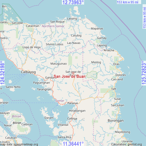
San Jose de Buan GPS coordinates[2]
12° 3' 10.44" North, 125° 1' 30.36" East
| Map corner | latitude | longitude |
|---|---|---|
| Upper-left | 12.73963°, | 124.32198° |
| Center: | 12.0529°, | 125.0251° |
| Lower-right: | 11.36441°, | 125.72823° |
| Map W x H: | 152.9×152.9 km | = 95×95mi |
| max Lat: | 20.78733° ⇑48% North |
| San Jose de Buan: | 12.0529° |
| min Lat: | ⇓52% South 4.65442° |
| min Long | San Jose de Bua | max Long |
| 117.04868° | 125.0251° | 126.58417° |
| W 88.2%⇐ | ⇒11.8% E |
Elevation
Elevation of San Jose de Buan is 139 m = 456 ft, and this is 51.1 m = 168 ft above average elevation for this country.
| Max E: |
2262 m = 7421 ft | 14.9% |
| San Jose de Buan | 139 m 456 ft | |
| Avg. | 87.9 m = 288 ft | |
Min E: |
-2 m = -7 ft | 85.1% |
See also: Philippines elevation on elevation.city.
Geographical zone
San Jose de Buan is located in North Torrid zone (between Equator and Tropic of Cancer). Distance of this Northern Tropic circle is 1265.8 km =786.5 mi to North.| Distance of | km | miles | from San Jose de Buan |
|---|---|---|---|
| North Pole | 8666.9 | 5385.4 | to North |
| Arctic Circle | 6061 | 3766.1 | to North |
| Tropic Cancer | 1265.8 | 786.5 | to North |
| Equator | 1340.2 | 832.8 | to South |


Nearby cities:
15 places around San Jose de Buan: (largest is in red/bold)
• Calape
12.3 km =7.6 mi,  181°
181°
• Catbalogan
34.4 km =21.4 mi,  206°
206°
• Gandara
23.6 km =14.7 mi,  259°
259°
• Hipadpad
34.6 km =21.5 mi,  41°
41°
• Jiabong
33.3 km =20.7 mi,  193°
193°
• Las Navas
31.8 km =19.8 mi,  1°
1°
• Maslog
25.1 km =15.6 mi,  64°
64°
• Motiong
30.5 km =19 mi, 185°
• Pagsanghan
34.4 km =21.4 mi,  253°
253°
• Paranas
24.6 km =15.3 mi,  156°
156°
• San Jorge
23.3 km =14.5 mi, 249°
• Silanga
32.8 km =20.4 mi,  217°
217°
• Silvino Lobos
34.5 km =21.4 mi,  322°
322°
• Tutubigan
24 km =14.9 mi,  170°
170°
• Wright
31.4 km =19.5 mi, 180°
Sources, notices
• [Note1] Compared only with cities in Philippines existing in our database
• [Src1] Map data: © OpenStreetMap contributors (CC-BY-SA)
• [Src2] Other city data from geonames.org with taken over terms of usage.
• [Src3] Geographical zone / Annual Mean Temperature by Robert A. Rohde @ Wikipedia
