Paranas geodata
Paranas (Eastern Visayas) is a seat of a third-order administrative division; located in Philippines in Asia/Manila (GMT+8) time zone. In our database, there are 4166 cities with bigger population. Compared to other cities in Philippines, 51.2% of cities are located further ↓South; 89.3% of cities are located further ←West and 86.1% of cities have lower elevation than Paranas. Note1
Administrative division(s):
- Level 1: Eastern Visayas
- Level 2: Province of Samar
- Level 3: Paranas (Wright)


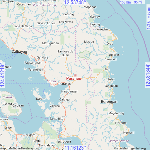
Paranas GPS coordinates[2]
11° 51' 0.792" North, 125° 6' 55.116" East
| Map corner | latitude | longitude |
|---|---|---|
| Upper-left | 12.53748°, | 124.41219° |
| Center: | 11.85022°, | 125.11531° |
| Lower-right: | 11.16123°, | 125.81844° |
| Map W x H: | 153×153 km | = 95.1×95.1mi |
| max Lat: | 20.78733° ⇑48.8% North |
| Paranas: | 11.85022° |
| min Lat: | ⇓51.2% South 4.65442° |
| min Long | Paranas | max Long |
| 117.04868° | 125.11531° | 126.58417° |
| W 89.3%⇐ | ⇒10.7% E |
Elevation
Elevation of Paranas is 152 m = 499 ft, and this is 64.1 m = 210 ft above average elevation for this country.
| Max E: |
2262 m = 7421 ft | 13.9% |
| Paranas | 152 m 499 ft | |
| Avg. | 87.9 m = 288 ft | |
Min E: |
-2 m = -7 ft | 86.1% |
See also: Philippines elevation on elevation.city.
Geographical zone
Paranas is located in North Torrid zone (between Equator and Tropic of Cancer). Distance of this Northern Tropic circle is 1288.3 km =800.5 mi to North.| Distance of | km | miles | from Paranas |
|---|---|---|---|
| North Pole | 8689.4 | 5399.3 | to North |
| Arctic Circle | 6083.6 | 3780.2 | to North |
| Tropic Cancer | 1288.3 | 800.5 | to North |
| Equator | 1317.6 | 818.7 | to South |


Nearby cities:
15 places around Paranas: (largest is in red/bold)
• Calape
14.5 km =9 mi,  315°
315°
• Calbiga
27.3 km =17 mi,  203°
203°
• Catbalogan
26.3 km =16.3 mi,  251°
251°
• Jiabong
20.3 km =12.6 mi,  241°
241°
• Mantang
34.1 km =21.2 mi,  86°
86°
• Motiong
14.8 km =9.2 mi, 238°
• Nena
34.2 km =21.3 mi,  105°
105°
• Pangdan
24.6 km =15.3 mi, 241°
• San Jorge
34.9 km =21.7 mi,  294°
294°
• San Jose de Buan
24.6 km =15.3 mi,  336°
336°
• San Sebastian
18.8 km =11.7 mi,  214°
214°
• Silanga
29.8 km =18.5 mi,  263°
263°
• Taft
33.5 km =20.8 mi,  80°
80°
• Tutubigan
6 km =3.7 mi, 258°
• Wright
13.5 km =8.4 mi,  228°
228°
Sources, notices
• [Note1] Compared only with cities in Philippines existing in our database
• [Src1] Map data: © OpenStreetMap contributors (CC-BY-SA)
• [Src2] Other city data from geonames.org with taken over terms of usage.
• [Src3] Geographical zone / Annual Mean Temperature by Robert A. Rohde @ Wikipedia
