Tutubigan geodata
Tutubigan (Eastern Visayas) is a populated place; located in Philippines in Asia/Manila (GMT+8) time zone. With population of 2,030 people, there are 4144 cities with bigger population in this country. Compared to other cities in Philippines, 51.1% of cities are located further ↓South; 88.9% of cities are located further ←West and 79.4% of cities have lower elevation than Tutubigan. Note1
Administrative division(s):
- Level 1: Eastern Visayas
- Level 2: Province of Samar
- Level 3: Paranas (Wright)


Tutubigan GPS coordinates[2]
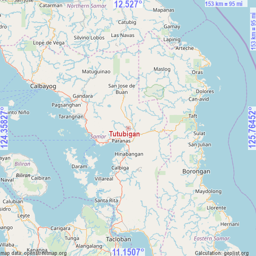
11° 50' 22.992" North, 125° 3' 41.004" East
| Map corner | latitude | longitude |
|---|---|---|
| Upper-left | 12.527°, | 124.35827° |
| Center: | 11.83972°, | 125.06139° |
| Lower-right: | 11.1507°, | 125.76452° |
| Map W x H: | 153×153 km | = 95.1×95.1mi |
| max Lat: | 20.78733° ⇑48.9% North |
| Tutubigan: | 11.83972° |
| min Lat: | ⇓51.1% South 4.65442° |
| min Long | Tutubigan | max Long |
| 117.04868° | 125.06139° | 126.58417° |
| W 88.9%⇐ | ⇒11.1% E |
Elevation
Elevation of Tutubigan is 88 m = 289 ft, and this is 0.099999999999994 m = 0 ft above average elevation for this country.
| Max E: |
2262 m = 7421 ft | 20.6% |
| Tutubigan | 88 m 289 ft | |
| Avg. | 87.9 m = 288 ft | |
Min E: |
-2 m = -7 ft | 79.4% |
See also: Philippines elevation on elevation.city.
Geographical zone
Tutubigan is located in North Torrid zone (between Equator and Tropic of Cancer). Distance of this Northern Tropic circle is 1289.5 km =801.3 mi to North.| Distance of | km | miles | from Tutubigan |
|---|---|---|---|
| North Pole | 8690.6 | 5400.1 | to North |
| Arctic Circle | 6084.7 | 3780.9 | to North |
| Tropic Cancer | 1289.5 | 801.3 | to North |
| Equator | 1316.5 | 818 | to South |


Nearby cities:
15 places around Tutubigan: (largest is in red/bold)
• Calape
12.2 km =7.6 mi,  339°
339°
• Calbiga
24.4 km =15.2 mi,  191°
191°
• Catbalogan
20.4 km =12.7 mi,  249°
249°
• Gandara
33.3 km =20.7 mi,  305°
305°
• Jiabong
14.7 km =9.1 mi,  234°
234°
• Motiong
9.4 km =5.8 mi, 225°
• Pangdan
19 km =11.8 mi,  236°
236°
• Paranas
6 km =3.7 mi,  78°
78°
• San Jorge
30.2 km =18.8 mi,  301°
301°
• San Jose de Buan
24 km =14.9 mi,  350°
350°
• San Sebastian
15.2 km =9.4 mi,  198°
198°
• Silanga
23.9 km =14.9 mi,  264°
264°
• Villareal
33.7 km =20.9 mi,  205°
205°
• Wright
8.8 km =5.5 mi, 209°
• Zumarraga
32.7 km =20.3 mi, 226°
Sources, notices
• [Note1] Compared only with cities in Philippines existing in our database
• [Src1] Map data: © OpenStreetMap contributors (CC-BY-SA)
• [Src2] Other city data from geonames.org with taken over terms of usage.
• [Src3] Geographical zone / Annual Mean Temperature by Robert A. Rohde @ Wikipedia
