Laug geodata
Laug (Central Luzon) is a populated place; located in Philippines in Asia/Manila (GMT+8) time zone. With population of 3,157 people, there are 2348 cities with bigger population in this country. Compared to other cities in Philippines, 78.2% of cities are located further ↓South; 83.6% of cities are located further →East and 85.4% of cities have higher elevation than Laug. Note1


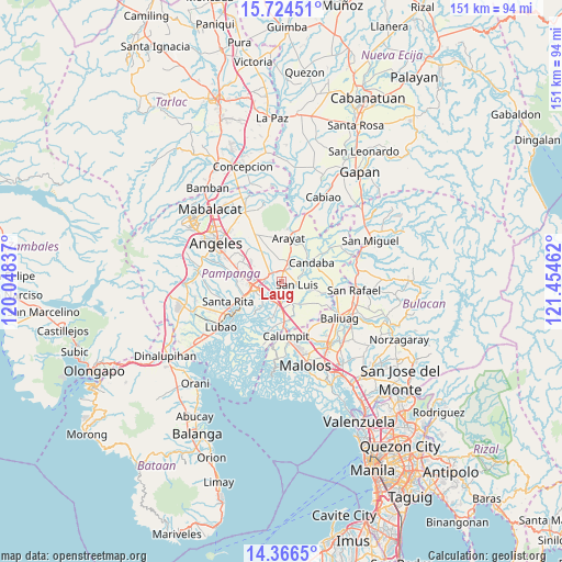
Laug GPS coordinates[2]
15° 2' 47.724" North, 120° 45' 5.364" East
| Map corner | latitude | longitude |
|---|---|---|
| Upper-left | 15.72451°, | 120.04837° |
| Center: | 15.04659°, | 120.75149° |
| Lower-right: | 14.3665°, | 121.45462° |
| Map W x H: | 151×151 km | = 93.8×93.8mi |
| max Lat: | 20.78733° ⇑21.8% North |
| Laug: | 15.04659° |
| min Lat: | ⇓78.2% South 4.65442° |
| min Long | Laug | max Long |
| 117.04868° | 120.75149° | 126.58417° |
| W 16.4%⇐ | ⇒83.6% E |
Elevation
Elevation of Laug is 8 m = 26 ft, and this is 79.9 m = 262 ft below average elevation for this country.
| Max E: |
2262 m = 7421 ft | 85.4% |
| Avg. | 87.9 m = 288 ft | |
| Laug | 8 m = 26 ft | |
Min E: |
-2 m = -7 ft | 14.6% |
See also: Philippines elevation on elevation.city.
Geographical zone
Laug is located in North Torrid zone (between Equator and Tropic of Cancer). Distance of this Northern Tropic circle is 932.9 km =579.7 mi to North.| Distance of | km | miles | from Laug |
|---|---|---|---|
| North Pole | 8334 | 5178.5 | to North |
| Arctic Circle | 5728.2 | 3559.3 | to North |
| Tropic Cancer | 932.9 | 579.7 | to North |
| Equator | 1673 | 1039.6 | to South |


Nearby cities:
15 places around Laug: (largest is in red/bold)
• Del Pilar
5.7 km =3.5 mi,  258°
258°
• Mexico
3.9 km =2.4 mi,  300°
300°
• Pau
3.6 km =2.2 mi,  234°
234°
• San Carlos
1.4 km =0.9 mi,  122°
122°
• San Fernando
7.3 km =4.5 mi, 259°
• San Jose
3.7 km =2.3 mi,  113°
113°
• San Luis
4 km =2.5 mi,  100°
100°
• San Nicolas
4.6 km =2.9 mi, 96°
• San Patricio
6.2 km =3.9 mi,  336°
336°
• San Simon
6.1 km =3.8 mi,  148°
148°
• Santa Ana
5.7 km =3.5 mi,  17°
17°
• Santa Maria
4.9 km =3 mi, 23°
• Santo Domingo
3 km =1.9 mi,  11°
11°
• Santo Domingo
6.2 km =3.9 mi,  188°
188°
• Santo Tomas
5.4 km =3.4 mi, 105°
Sources, notices
• [Note1] Compared only with cities in Philippines existing in our database
• [Src1] Map data: © OpenStreetMap contributors (CC-BY-SA)
• [Src2] Other city data from geonames.org with taken over terms of usage.
• [Src3] Geographical zone / Annual Mean Temperature by Robert A. Rohde @ Wikipedia
