Mexico geodata
Mexico (Central Luzon) is a seat of a third-order administrative division; located in Philippines in Asia/Manila (GMT+8) time zone. With population of 43,694 people, there are 196 cities with bigger population in this country. Compared to other cities in Philippines, 78.3% of cities are located further ↓South; 84.4% of cities are located further →East and 70.2% of cities have higher elevation than Mexico. Note1


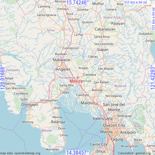
Mexico GPS coordinates[2]
15° 3' 52.56" North, 120° 43' 11.28" East
| Map corner | latitude | longitude |
|---|---|---|
| Upper-left | 15.74246°, | 120.01668° |
| Center: | 15.0646°, | 120.7198° |
| Lower-right: | 14.38457°, | 121.42293° |
| Map W x H: | 151×151 km | = 93.8×93.8mi |
| max Lat: | 20.78733° ⇑21.7% North |
| Mexico: | 15.0646° |
| min Lat: | ⇓78.3% South 4.65442° |
| min Long | Mexico | max Long |
| 117.04868° | 120.7198° | 126.58417° |
| W 15.6%⇐ | ⇒84.4% E |
Elevation
Elevation of Mexico is 12 m = 39 ft, and this is 75.9 m = 249 ft below average elevation for this country.
| Max E: |
2262 m = 7421 ft | 70.2% |
| Avg. | 87.9 m = 288 ft | |
| Mexico | 12 m = 39 ft | |
Min E: |
-2 m = -7 ft | 29.8% |
See also: Mexico elevation on elevation.city.
Geographical zone
Mexico is located in North Torrid zone (between Equator and Tropic of Cancer). Distance of this Northern Tropic circle is 930.9 km =578.4 mi to North.| Distance of | km | miles | from Mexico |
|---|---|---|---|
| North Pole | 8332 | 5177.3 | to North |
| Arctic Circle | 5726.1 | 3558 | to North |
| Tropic Cancer | 930.9 | 578.4 | to North |
| Equator | 1675 | 1040.8 | to South |


Nearby cities:
15 places around Mexico: (largest is in red/bold)
• Bulaon
6.4 km =4 mi,  288°
288°
• Del Pilar
3.9 km =2.4 mi,  214°
214°
• Laug
3.9 km =2.4 mi,  120°
120°
• Magliman
6.8 km =4.2 mi,  241°
241°
• Pau
4.1 km =2.5 mi,  173°
173°
• San Carlos
5.4 km =3.4 mi, 120°
• San Fernando
5.1 km =3.2 mi,  228°
228°
• San Jose
7.7 km =4.8 mi, 117°
• San Juan
6.5 km =4 mi,  224°
224°
• San Luis
7.8 km =4.8 mi,  110°
110°
• San Nicolas
8.4 km =5.2 mi, 107°
• San Patricio
3.8 km =2.4 mi,  14°
14°
• Santa Ana
6.1 km =3.8 mi,  55°
55°
• Santa Maria
5.9 km =3.7 mi,  65°
65°
• Santo Domingo
4.1 km =2.5 mi,  77°
77°
Sources, notices
• [Note1] Compared only with cities in Philippines existing in our database
• [Src1] Map data: © OpenStreetMap contributors (CC-BY-SA)
• [Src2] Other city data from geonames.org with taken over terms of usage.
• [Src3] Geographical zone / Annual Mean Temperature by Robert A. Rohde @ Wikipedia
