San Fernando geodata
San Fernando (Central Luzon) is a seat of a first-order administrative division; located in Philippines in Asia/Manila (GMT+8) time zone. With population of 251,248 people, there are 37 cities with bigger population in this country. Compared to other cities in Philippines, 78% of cities are located further ↓South; 85.4% of cities are located further →East and 76.6% of cities have higher elevation than San Fernando. Note1
Administrative division(s):
- Level 1: Central Luzon
- Level 2: Province of Pampanga
- Level 3: City of San Fernando


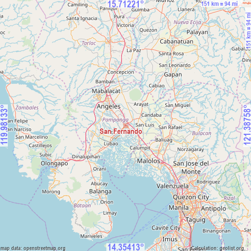
San Fernando GPS coordinates[2]
15° 2' 3.3" North, 120° 41' 4.02" East
| Map corner | latitude | longitude |
|---|---|---|
| Upper-left | 15.71221°, | 119.98133° |
| Center: | 15.03425°, | 120.68445° |
| Lower-right: | 14.35413°, | 121.38758° |
| Map W x H: | 151×151 km | = 93.8×93.8mi |
| max Lat: | 20.78733° ⇑22% North |
| San Fernando: | 15.03425° |
| min Lat: | ⇓78% South 4.65442° |
| min Long | San Fernando | max Long |
| 117.04868° | 120.68445° | 126.58417° |
| W 14.6%⇐ | ⇒85.4% E |
Elevation
Elevation of San Fernando is 10 m = 33 ft, and this is 77.9 m = 256 ft below average elevation for this country.
| Max E: |
2262 m = 7421 ft | 76.6% |
| Avg. | 87.9 m = 288 ft | |
| San Fernando | 10 m = 33 ft | |
Min E: |
-2 m = -7 ft | 23.4% |
See also: San Fernando elevation on elevation.city.
Geographical zone
San Fernando is located in North Torrid zone (between Equator and Tropic of Cancer). Distance of this Northern Tropic circle is 934.3 km =580.5 mi to North.| Distance of | km | miles | from San Fernando |
|---|---|---|---|
| North Pole | 8335.4 | 5179.4 | to North |
| Arctic Circle | 5729.5 | 3560.1 | to North |
| Tropic Cancer | 934.3 | 580.5 | to North |
| Equator | 1671.7 | 1038.7 | to South |


Nearby cities:
15 places around San Fernando: (largest is in red/bold)
• Bacolor
5.1 km =3.2 mi,  222°
222°
• Bulaon
5.9 km =3.7 mi,  336°
336°
• Del Pilar
1.6 km =1 mi,  83°
83°
• Laug
7.3 km =4.5 mi, 79°
• Lourdes
7.5 km =4.7 mi,  180°
180°
• Magliman
2.2 km =1.4 mi,  273°
273°
• Mexico
5.1 km =3.2 mi,  48°
48°
• Minalin
7.4 km =4.6 mi, 181°
• Pau
4.3 km =2.7 mi,  99°
99°
• San Carlos
8.4 km =5.2 mi,  85°
85°
• San Juan
1.5 km =0.9 mi,  212°
212°
• San Patricio
8.5 km =5.3 mi,  33°
33°
• Santa Rita
8.7 km =5.4 mi,  243°
243°
• Santo Domingo
7.9 km =4.9 mi,  127°
127°
• Santo Domingo
8.9 km =5.5 mi,  61°
61°
Sources, notices
• [Note1] Compared only with cities in Philippines existing in our database
• [Src1] Map data: © OpenStreetMap contributors (CC-BY-SA)
• [Src2] Other city data from geonames.org with taken over terms of usage.
• [Src3] Geographical zone / Annual Mean Temperature by Robert A. Rohde @ Wikipedia
