Sandiat Centro geodata
Sandiat Centro (Cagayan Valley) is a populated place; located in Philippines in Asia/Manila (GMT+8) time zone. With population of 4,910 people, there are 1334 cities with bigger population in this country. Compared to other cities in Philippines, 93.9% of cities are located further ↓South; 64.9% of cities are located further →East and 72.4% of cities have lower elevation than Sandiat Centro. Note1
Administrative division(s):
- Level 1: Cagayan Valley
- Level 2: Province of Isabela
- Level 3: San Manuel


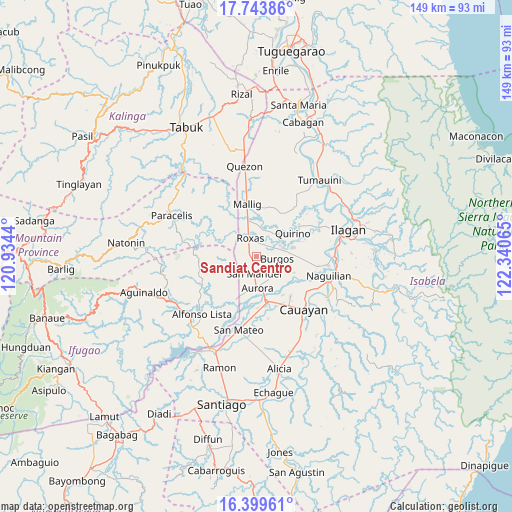
Sandiat Centro GPS coordinates[2]
17° 4' 22.62" North, 121° 38' 15.072" East
| Map corner | latitude | longitude |
|---|---|---|
| Upper-left | 17.74386°, | 120.9344° |
| Center: | 17.07295°, | 121.63752° |
| Lower-right: | 16.39961°, | 122.34065° |
| Map W x H: | 149.5×149.5 km | = 92.9×92.9mi |
| max Lat: | 20.78733° ⇑6.1% North |
| Sandiat Centro: | 17.07295° |
| min Lat: | ⇓93.9% South 4.65442° |
| min Long | Sandiat Centro | max Long |
| 117.04868° | 121.63752° | 126.58417° |
| W 35.1%⇐ | ⇒64.9% E |
Elevation
Elevation of Sandiat Centro is 59 m = 194 ft, and this is 28.9 m = 95 ft below average elevation for this country.
| Max E: |
2262 m = 7421 ft | 27.6% |
| Avg. | 87.9 m = 288 ft | |
| Sandiat Centro | 59 m = 194 ft | |
Min E: |
-2 m = -7 ft | 72.4% |
See also: Philippines elevation on elevation.city.
Geographical zone
Sandiat Centro is located in North Torrid zone (between Equator and Tropic of Cancer). Distance of this Northern Tropic circle is 707.6 km =439.7 mi to North.| Distance of | km | miles | from Sandiat Centro |
|---|---|---|---|
| North Pole | 8108.7 | 5038.5 | to North |
| Arctic Circle | 5502.8 | 3419.3 | to North |
| Tropic Cancer | 707.6 | 439.7 | to North |
| Equator | 1898.3 | 1179.5 | to South |


Nearby cities:
15 places around Sandiat Centro: (largest is in red/bold)
• Aurora
9.2 km =5.7 mi,  180°
180°
• Bacnor East
8.2 km =5.1 mi,  121°
121°
• Bagong Tanza
10.4 km =6.5 mi,  195°
195°
• Burgos
7.1 km =4.4 mi,  75°
75°
• Cabatuan
13.4 km =8.3 mi,  165°
165°
• Cullalabo del Sur
7.8 km =4.8 mi,  64°
64°
• Eden
5.7 km =3.5 mi,  227°
227°
• Esperanza East
7.4 km =4.6 mi,  138°
138°
• Mabini
10.7 km =6.6 mi,  74°
74°
• Muñoz East
9.7 km =6 mi,  344°
344°
• Quirino
9.4 km =5.8 mi,  44°
44°
• Roxas
5.4 km =3.4 mi, 340°
• San Jose
9.4 km =5.8 mi, 335°
• San Manuel
5.5 km =3.4 mi, 181°
• Simimbaan
7.8 km =4.8 mi,  310°
310°
Sources, notices
• [Note1] Compared only with cities in Philippines existing in our database
• [Src1] Map data: © OpenStreetMap contributors (CC-BY-SA)
• [Src2] Other city data from geonames.org with taken over terms of usage.
• [Src3] Geographical zone / Annual Mean Temperature by Robert A. Rohde @ Wikipedia
