Cullalabo del Sur geodata
Cullalabo del Sur (Cagayan Valley) is a populated place; located in Philippines in Asia/Manila (GMT+8) time zone. With population of 4,907 people, there are 1336 cities with bigger population in this country. Compared to other cities in Philippines, 94.1% of cities are located further ↓South; 63.9% of cities are located further →East and 71.2% of cities have lower elevation than Cullalabo del Sur. Note1


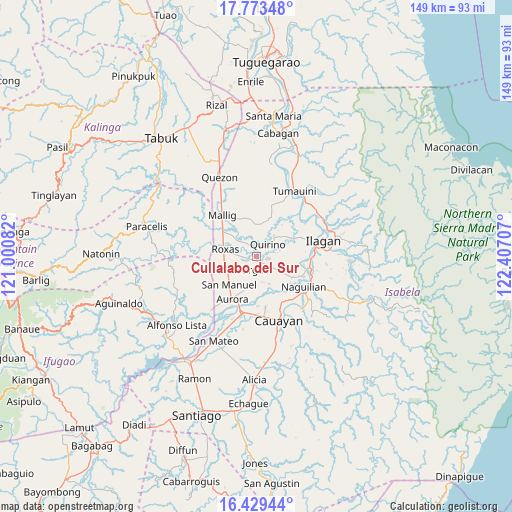
Cullalabo del Sur GPS coordinates[2]
17° 6' 9.612" North, 121° 42' 14.184" East
| Map corner | latitude | longitude |
|---|---|---|
| Upper-left | 17.77348°, | 121.00082° |
| Center: | 17.10267°, | 121.70394° |
| Lower-right: | 16.42944°, | 122.40707° |
| Map W x H: | 149.4×149.4 km | = 92.8×92.8mi |
| max Lat: | 20.78733° ⇑5.9% North |
| Cullalabo del Sur: | 17.10267° |
| min Lat: | ⇓94.1% South 4.65442° |
| min Long | Cullalabo del S | max Long |
| 117.04868° | 121.70394° | 126.58417° |
| W 36.1%⇐ | ⇒63.9% E |
Elevation
Elevation of Cullalabo del Sur is 55 m = 180 ft, and this is 32.9 m = 108 ft below average elevation for this country.
| Max E: |
2262 m = 7421 ft | 28.8% |
| Avg. | 87.9 m = 288 ft | |
| Cullalabo del Sur | 55 m = 180 ft | |
Min E: |
-2 m = -7 ft | 71.2% |
See also: Philippines elevation on elevation.city.
Geographical zone
Cullalabo del Sur is located in North Torrid zone (between Equator and Tropic of Cancer). Distance of this Northern Tropic circle is 704.3 km =437.6 mi to North.| Distance of | km | miles | from Cullalabo del Sur |
|---|---|---|---|
| North Pole | 8105.4 | 5036.5 | to North |
| Arctic Circle | 5499.5 | 3417.2 | to North |
| Tropic Cancer | 704.3 | 437.6 | to North |
| Equator | 1901.6 | 1181.6 | to South |


Nearby cities:
15 places around Cullalabo del Sur: (largest is in red/bold)
• Bacnor East
7.6 km =4.7 mi,  180°
180°
• Banquero
11.9 km =7.4 mi,  138°
138°
• Burgos
1.5 km =0.9 mi,  185°
185°
• Esperanza East
9.1 km =5.7 mi, 193°
• Furao
12.4 km =7.7 mi,  127°
127°
• Mabini
3.3 km =2.1 mi,  96°
96°
• Muñoz East
11.4 km =7.1 mi,  302°
302°
• Quirino
3.4 km =2.1 mi,  352°
352°
• Roxas
9.1 km =5.7 mi,  281°
281°
• San Jose
12.2 km =7.6 mi, 295°
• San Manuel
11.4 km =7.1 mi,  219°
219°
• San Mateo
5.9 km =3.7 mi,  48°
48°
• Sandiat Centro
7.8 km =4.8 mi,  244°
244°
• Santo Domingo
8.2 km =5.1 mi,  38°
38°
• Simimbaan
13.1 km =8.1 mi, 277°
Sources, notices
• [Note1] Compared only with cities in Philippines existing in our database
• [Src1] Map data: © OpenStreetMap contributors (CC-BY-SA)
• [Src2] Other city data from geonames.org with taken over terms of usage.
• [Src3] Geographical zone / Annual Mean Temperature by Robert A. Rohde @ Wikipedia
