Aurora geodata
Aurora (Cagayan Valley) is a seat of a third-order administrative division; located in Philippines in Asia/Manila (GMT+8) time zone. With population of 4,500 people, there are 1490 cities with bigger population in this country. Compared to other cities in Philippines, 93.5% of cities are located further ↓South; 64.9% of cities are located further →East and 73.6% of cities have lower elevation than Aurora. Note1


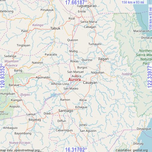
Aurora GPS coordinates[2]
16° 59' 26.34" North, 121° 38' 11.904" East
| Map corner | latitude | longitude |
|---|---|---|
| Upper-left | 17.66187°, | 120.93352° |
| Center: | 16.99065°, | 121.63664° |
| Lower-right: | 16.31702°, | 122.33977° |
| Map W x H: | 149.5×149.5 km | = 92.9×92.9mi |
| max Lat: | 20.78733° ⇑6.5% North |
| Aurora: | 16.99065° |
| min Lat: | ⇓93.5% South 4.65442° |
| min Long | Aurora | max Long |
| 117.04868° | 121.63664° | 126.58417° |
| W 35.1%⇐ | ⇒64.9% E |
Elevation
Elevation of Aurora is 63 m = 207 ft, and this is 24.9 m = 82 ft below average elevation for this country.
| Max E: |
2262 m = 7421 ft | 26.4% |
| Avg. | 87.9 m = 288 ft | |
| Aurora | 63 m = 207 ft | |
Min E: |
-2 m = -7 ft | 73.6% |
See also: Philippines elevation on elevation.city.
Geographical zone
Aurora is located in North Torrid zone (between Equator and Tropic of Cancer). Distance of this Northern Tropic circle is 716.7 km =445.3 mi to North.| Distance of | km | miles | from Aurora |
|---|---|---|---|
| North Pole | 8117.9 | 5044.2 | to North |
| Arctic Circle | 5512 | 3425 | to North |
| Tropic Cancer | 716.7 | 445.3 | to North |
| Equator | 1889.2 | 1173.9 | to South |


Nearby cities:
15 places around Aurora: (largest is in red/bold)
• Bacnor East
8.6 km =5.3 mi,  55°
55°
• Bagong Tanza
2.9 km =1.8 mi,  251°
251°
• Burgos
13 km =8.1 mi,  32°
32°
• Cabatuan
5.1 km =3.2 mi,  138°
138°
• Diamantina
8.2 km =5.1 mi,  187°
187°
• Eden
6.7 km =4.2 mi,  322°
322°
• Esperanza East
6.2 km =3.9 mi,  54°
54°
• La Paz
9.5 km =5.9 mi,  159°
159°
• Luna
10.1 km =6.3 mi,  103°
103°
• Magdalena
5.3 km =3.3 mi, 144°
• Nagrumbuan
12.8 km =8 mi, 142°
• San Manuel
3.7 km =2.3 mi,  358°
358°
• San Mateo
13.2 km =8.2 mi,  203°
203°
• Sandiat Centro
9.2 km =5.7 mi,  0°
0°
• Sinamar
12.5 km =7.8 mi,  216°
216°
Sources, notices
• [Note1] Compared only with cities in Philippines existing in our database
• [Src1] Map data: © OpenStreetMap contributors (CC-BY-SA)
• [Src2] Other city data from geonames.org with taken over terms of usage.
• [Src3] Geographical zone / Annual Mean Temperature by Robert A. Rohde @ Wikipedia
