San Carlos geodata
San Carlos (Central Luzon) is a populated place; located in Philippines in Asia/Manila (GMT+8) time zone. With population of 2,536 people, there are 3236 cities with bigger population in this country. Compared to other cities in Philippines, 82.1% of cities are located further ↓South; 79.6% of cities are located further →East and 62.2% of cities have lower elevation than San Carlos. Note1


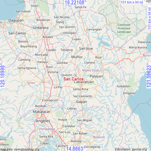
San Carlos GPS coordinates[2]
15° 32' 41.28" North, 120° 53' 35.16" East
| Map corner | latitude | longitude |
|---|---|---|
| Upper-left | 16.22108°, | 120.18998° |
| Center: | 15.5448°, | 120.8931° |
| Lower-right: | 14.8663°, | 121.59623° |
| Map W x H: | 150.6×150.6 km | = 93.6×93.6mi |
| max Lat: | 20.78733° ⇑17.9% North |
| San Carlos: | 15.5448° |
| min Lat: | ⇓82.1% South 4.65442° |
| min Long | San Carlos | max Long |
| 117.04868° | 120.8931° | 126.58417° |
| W 20.4%⇐ | ⇒79.6% E |
Elevation
Elevation of San Carlos is 37 m = 121 ft, and this is 50.9 m = 167 ft below average elevation for this country.
| Max E: |
2262 m = 7421 ft | 37.8% |
| Avg. | 87.9 m = 288 ft | |
| San Carlos | 37 m = 121 ft | |
Min E: |
-2 m = -7 ft | 62.2% |
See also: Philippines elevation on elevation.city.
Geographical zone
San Carlos is located in North Torrid zone (between Equator and Tropic of Cancer). Distance of this Northern Tropic circle is 877.5 km =545.3 mi to North.| Distance of | km | miles | from San Carlos |
|---|---|---|---|
| North Pole | 8278.6 | 5144.1 | to North |
| Arctic Circle | 5672.8 | 3524.9 | to North |
| Tropic Cancer | 877.5 | 545.3 | to North |
| Equator | 1728.4 | 1074 | to South |


Nearby cities:
15 places around San Carlos: (largest is in red/bold)
• Aliaga
7.3 km =4.5 mi,  227°
227°
• Baloc
11 km =6.8 mi,  355°
355°
• Bibiclat
4.2 km =2.6 mi, 232°
• Buliran
7.1 km =4.4 mi,  88°
88°
• Cabanatuan City
10.2 km =6.3 mi,  129°
129°
• Mabini
11.4 km =7.1 mi,  57°
57°
• Quezon
8.4 km =5.2 mi,  274°
274°
• San Alejandro
5.1 km =3.2 mi,  290°
290°
• San Fabian
5.9 km =3.7 mi,  14°
14°
• San Felipe Old
5.1 km =3.2 mi,  161°
161°
• San Ricardo
10.2 km =6.3 mi, 56°
• Santa Maria
11 km =6.8 mi,  257°
257°
• Santa Rita
8.6 km =5.3 mi,  343°
343°
• Santo Domingo
5 km =3.1 mi, 339°
• Talavera
5.6 km =3.5 mi,  30°
30°
Sources, notices
• [Note1] Compared only with cities in Philippines existing in our database
• [Src1] Map data: © OpenStreetMap contributors (CC-BY-SA)
• [Src2] Other city data from geonames.org with taken over terms of usage.
• [Src3] Geographical zone / Annual Mean Temperature by Robert A. Rohde @ Wikipedia
