Bibiclat geodata
Bibiclat (Central Luzon) is a populated place; located in Philippines in Asia/Manila (GMT+8) time zone. With population of 7,039 people, there are 889 cities with bigger population in this country. Compared to other cities in Philippines, 81.9% of cities are located further ↓South; 80.6% of cities are located further →East and 59.5% of cities have lower elevation than Bibiclat. Note1


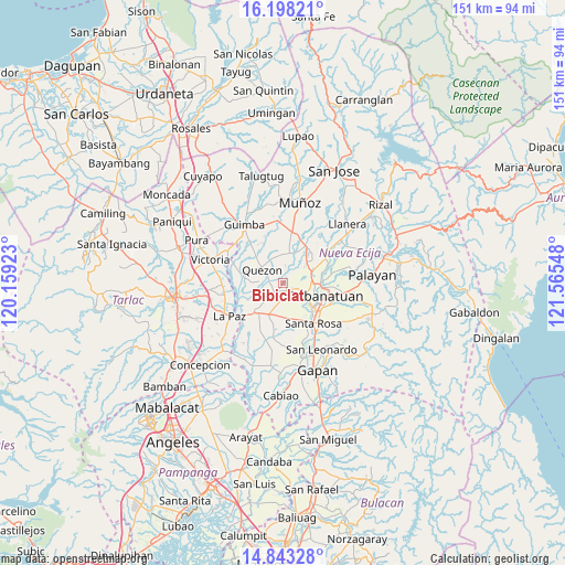
Bibiclat GPS coordinates[2]
15° 31' 18.696" North, 120° 51' 44.46" East
| Map corner | latitude | longitude |
|---|---|---|
| Upper-left | 16.19821°, | 120.15923° |
| Center: | 15.52186°, | 120.86235° |
| Lower-right: | 14.84328°, | 121.56548° |
| Map W x H: | 150.7×150.7 km | = 93.6×93.6mi |
| max Lat: | 20.78733° ⇑18.1% North |
| Bibiclat: | 15.52186° |
| min Lat: | ⇓81.9% South 4.65442° |
| min Long | Bibiclat | max Long |
| 117.04868° | 120.86235° | 126.58417° |
| W 19.4%⇐ | ⇒80.6% E |
Elevation
Elevation of Bibiclat is 33 m = 108 ft, and this is 54.9 m = 180 ft below average elevation for this country.
| Max E: |
2262 m = 7421 ft | 40.5% |
| Avg. | 87.9 m = 288 ft | |
| Bibiclat | 33 m = 108 ft | |
Min E: |
-2 m = -7 ft | 59.5% |
See also: Philippines elevation on elevation.city.
Geographical zone
Bibiclat is located in North Torrid zone (between Equator and Tropic of Cancer). Distance of this Northern Tropic circle is 880 km =546.8 mi to North.| Distance of | km | miles | from Bibiclat |
|---|---|---|---|
| North Pole | 8281.2 | 5145.7 | to North |
| Arctic Circle | 5675.3 | 3526.5 | to North |
| Tropic Cancer | 880 | 546.8 | to North |
| Equator | 1725.9 | 1072.4 | to South |


Nearby cities:
15 places around Bibiclat: (largest is in red/bold)
• Aliaga
3.2 km =2 mi,  220°
220°
• Buliran
10.8 km =6.7 mi,  75°
75°
• Carmen
9.2 km =5.7 mi,  204°
204°
• Quezon
6.1 km =3.8 mi,  302°
302°
• Rajal Norte
8.6 km =5.3 mi,  179°
179°
• San Alejandro
4.6 km =2.9 mi,  341°
341°
• San Carlos
4.2 km =2.6 mi,  52°
52°
• San Casimiro
9.4 km =5.8 mi,  291°
291°
• San Fabian
9.5 km =5.9 mi,  29°
29°
• San Felipe Old
5.4 km =3.4 mi,  115°
115°
• Santa Lucia
10.4 km =6.5 mi,  244°
244°
• Santa Maria
7.5 km =4.7 mi,  271°
271°
• Santo Domingo
7.4 km =4.6 mi,  12°
12°
• Santo Rosario
10.2 km =6.3 mi,  163°
163°
• Talavera
9.6 km =6 mi,  39°
39°
Sources, notices
• [Note1] Compared only with cities in Philippines existing in our database
• [Src1] Map data: © OpenStreetMap contributors (CC-BY-SA)
• [Src2] Other city data from geonames.org with taken over terms of usage.
• [Src3] Geographical zone / Annual Mean Temperature by Robert A. Rohde @ Wikipedia
