Baloc geodata
Baloc (Central Luzon) is a populated place; located in Philippines in Asia/Manila (GMT+8) time zone. With population of 10,566 people, there are 585 cities with bigger population in this country. Compared to other cities in Philippines, 83.2% of cities are located further ↓South; 79.8% of cities are located further →East and 70.8% of cities have lower elevation than Baloc. Note1
Administrative division(s):
- Level 1: Central Luzon
- Level 2: Province of Nueva Ecija
- Level 3: Santo Domingo


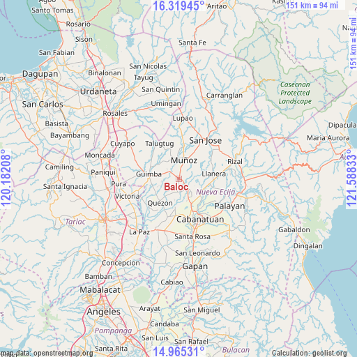
Baloc GPS coordinates[2]
15° 38' 36.6" North, 120° 53' 6.72" East
| Map corner | latitude | longitude |
|---|---|---|
| Upper-left | 16.31945°, | 120.18208° |
| Center: | 15.6435°, | 120.8852° |
| Lower-right: | 14.96531°, | 121.58833° |
| Map W x H: | 150.6×150.6 km | = 93.6×93.6mi |
| max Lat: | 20.78733° ⇑16.8% North |
| Baloc: | 15.6435° |
| min Lat: | ⇓83.2% South 4.65442° |
| min Long | Baloc | max Long |
| 117.04868° | 120.8852° | 126.58417° |
| W 20.2%⇐ | ⇒79.8% E |
Elevation
Elevation of Baloc is 54 m = 177 ft, and this is 33.9 m = 111 ft below average elevation for this country.
| Max E: |
2262 m = 7421 ft | 29.2% |
| Avg. | 87.9 m = 288 ft | |
| Baloc | 54 m = 177 ft | |
Min E: |
-2 m = -7 ft | 70.8% |
See also: Philippines elevation on elevation.city.
Geographical zone
Baloc is located in North Torrid zone (between Equator and Tropic of Cancer). Distance of this Northern Tropic circle is 866.5 km =538.4 mi to North.| Distance of | km | miles | from Baloc |
|---|---|---|---|
| North Pole | 8267.7 | 5137.3 | to North |
| Arctic Circle | 5661.8 | 3518.1 | to North |
| Tropic Cancer | 866.5 | 538.4 | to North |
| Equator | 1739.4 | 1080.8 | to South |


Nearby cities:
15 places around Baloc: (largest is in red/bold)
• Bunol
6 km =3.7 mi,  295°
295°
• Maligaya
3.5 km =2.2 mi,  6°
6°
• Manacsac
11.4 km =7.1 mi,  241°
241°
• Maturanoc
10.1 km =6.3 mi,  278°
278°
• Muñoz
8.3 km =5.2 mi, 13°
• Palusapis
5 km =3.1 mi,  331°
331°
• San Alejandro
10 km =6.2 mi,  202°
202°
• San Carlos
11 km =6.8 mi,  175°
175°
• San Fabian
5.7 km =3.5 mi,  156°
156°
• San Ricardo
10.8 km =6.7 mi,  119°
119°
• Santa Rita
3.2 km =2 mi,  211°
211°
• Santo Domingo
6.3 km =3.9 mi,  187°
187°
• Santo Rosario
2.6 km =1.6 mi,  272°
272°
• Tabacao
6 km =3.7 mi,  83°
83°
• Talavera
7.1 km =4.4 mi,  149°
149°
Sources, notices
• [Note1] Compared only with cities in Philippines existing in our database
• [Src1] Map data: © OpenStreetMap contributors (CC-BY-SA)
• [Src2] Other city data from geonames.org with taken over terms of usage.
• [Src3] Geographical zone / Annual Mean Temperature by Robert A. Rohde @ Wikipedia
