San Alejandro geodata
San Alejandro (Central Luzon) is a populated place; located in Philippines in Asia/Manila (GMT+8) time zone. With population of 3,064 people, there are 2454 cities with bigger population in this country. Compared to other cities in Philippines, 82.3% of cities are located further ↓South; 81.1% of cities are located further →East and 59.5% of cities have lower elevation than San Alejandro. Note1


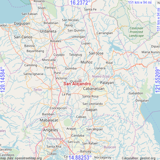
San Alejandro GPS coordinates[2]
15° 33' 39.528" North, 120° 50' 56.256" East
| Map corner | latitude | longitude |
|---|---|---|
| Upper-left | 16.2372°, | 120.14584° |
| Center: | 15.56098°, | 120.84896° |
| Lower-right: | 14.88253°, | 121.55209° |
| Map W x H: | 150.6×150.6 km | = 93.6×93.6mi |
| max Lat: | 20.78733° ⇑17.7% North |
| San Alejandro: | 15.56098° |
| min Lat: | ⇓82.3% South 4.65442° |
| min Long | San Alejandro | max Long |
| 117.04868° | 120.84896° | 126.58417° |
| W 18.9%⇐ | ⇒81.1% E |
Elevation
Elevation of San Alejandro is 33 m = 108 ft, and this is 54.9 m = 180 ft below average elevation for this country.
| Max E: |
2262 m = 7421 ft | 40.5% |
| Avg. | 87.9 m = 288 ft | |
| San Alejandro | 33 m = 108 ft | |
Min E: |
-2 m = -7 ft | 59.5% |
See also: Philippines elevation on elevation.city.
Geographical zone
San Alejandro is located in North Torrid zone (between Equator and Tropic of Cancer). Distance of this Northern Tropic circle is 875.7 km =544.1 mi to North.| Distance of | km | miles | from San Alejandro |
|---|---|---|---|
| North Pole | 8276.8 | 5143 | to North |
| Arctic Circle | 5671 | 3523.8 | to North |
| Tropic Cancer | 875.7 | 544.1 | to North |
| Equator | 1730.2 | 1075.1 | to South |


Nearby cities:
15 places around San Alejandro: (largest is in red/bold)
• Aliaga
6.8 km =4.2 mi,  185°
185°
• Bibiclat
4.6 km =2.9 mi,  161°
161°
• Licab
9.4 km =5.8 mi,  258°
258°
• Manacsac
7.3 km =4.5 mi,  301°
301°
• Quezon
3.8 km =2.4 mi,  253°
253°
• San Carlos
5.1 km =3.2 mi,  110°
110°
• San Casimiro
7.4 km =4.6 mi, 263°
• San Cristobal
8.8 km =5.5 mi, 264°
• San Fabian
7.3 km =4.5 mi,  57°
57°
• San Felipe Old
9.1 km =5.7 mi,  136°
136°
• Santa Maria
7.4 km =4.6 mi,  235°
235°
• Santa Rita
6.8 km =4.2 mi,  18°
18°
• Santo Domingo
4.2 km =2.6 mi,  45°
45°
• Santo Rosario
9.4 km =5.8 mi,  8°
8°
• Talavera
8.1 km =5 mi,  68°
68°
Sources, notices
• [Note1] Compared only with cities in Philippines existing in our database
• [Src1] Map data: © OpenStreetMap contributors (CC-BY-SA)
• [Src2] Other city data from geonames.org with taken over terms of usage.
• [Src3] Geographical zone / Annual Mean Temperature by Robert A. Rohde @ Wikipedia
