San Carlos geodata
San Carlos (Northern Mindanao) is a populated place; located in Philippines in Asia/Manila (GMT+8) time zone. With population of 3,186 people, there are 2324 cities with bigger population in this country. Compared to other cities in Philippines, 83.1% of cities are located further ↑North; 89.1% of cities are located further ←West and 94.3% of cities have lower elevation than San Carlos. Note1
Administrative division(s):
- Level 1: Northern Mindanao
- Level 2: Province of Bukidnon
- Level 3: City of Valencia


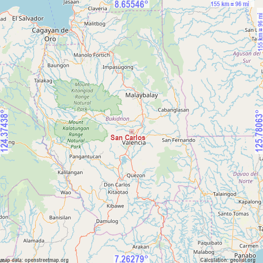
San Carlos GPS coordinates[2]
7° 57' 34.992" North, 125° 4' 39" East
| Map corner | latitude | longitude |
|---|---|---|
| Upper-left | 8.65546°, | 124.37438° |
| Center: | 7.95972°, | 125.0775° |
| Lower-right: | 7.26279°, | 125.78063° |
| Map W x H: | 154.9×154.9 km | = 96.3×96.3mi |
| max Lat: | 20.78733° ⇑83.1% North |
| San Carlos: | 7.95972° |
| min Lat: | ⇓16.9% South 4.65442° |
| min Long | San Carlos | max Long |
| 117.04868° | 125.0775° | 126.58417° |
| W 89.1%⇐ | ⇒10.9% E |
Elevation
Elevation of San Carlos is 383 m = 1257 ft, and this is 295.1 m = 968 ft above average elevation for this country.
| Max E: |
2262 m = 7421 ft | 5.7% |
| San Carlos | 383 m 1257 ft | |
| Avg. | 87.9 m = 288 ft | |
Min E: |
-2 m = -7 ft | 94.3% |
See also: Philippines elevation on elevation.city.
Geographical zone
San Carlos is located in North Torrid zone (between Equator and Tropic of Cancer). Distance of Equator is 885 km =549.9 mi to South.| Distance of | km | miles | from San Carlos |
|---|---|---|---|
| North Pole | 9122 | 5668.1 | to North |
| Arctic Circle | 6516.1 | 4048.9 | to North |
| Tropic Cancer | 1720.9 | 1069.3 | to North |
| Equator | 885 | 549.9 | to South |


Nearby cities:
15 places around San Carlos: (largest is in red/bold)
• Aglayan
12.3 km =7.6 mi,  30°
30°
• Alanib
12.6 km =7.8 mi,  306°
306°
• Balila
8.6 km =5.3 mi,  304°
304°
• Bantuanon
6.2 km =3.9 mi,  353°
353°
• Bugcaon
10.3 km =6.4 mi,  22°
22°
• Cabangahan
9.6 km =6 mi,  43°
43°
• Dologon
13.7 km =8.5 mi,  195°
195°
• Laguitas
15.5 km =9.6 mi, 22°
• Lantapan
6.9 km =4.3 mi, 307°
• Linabo
13.5 km =8.4 mi, 39°
• Lumbayao
11.7 km =7.3 mi,  57°
57°
• Lurugan
13.7 km =8.5 mi, 297°
• Mailag
6.7 km =4.2 mi,  79°
79°
• Managok
14.5 km =9 mi, 57°
• NIA Valencia
6.2 km =3.9 mi,  162°
162°
Sources, notices
• [Note1] Compared only with cities in Philippines existing in our database
• [Src1] Map data: © OpenStreetMap contributors (CC-BY-SA)
• [Src2] Other city data from geonames.org with taken over terms of usage.
• [Src3] Geographical zone / Annual Mean Temperature by Robert A. Rohde @ Wikipedia
