Lumbayao geodata
Lumbayao (Northern Mindanao) is a populated place; located in Philippines in Asia/Manila (GMT+8) time zone. With population of 3,693 people, there are 1924 cities with bigger population in this country. Compared to other cities in Philippines, 82.6% of cities are located further ↑North; 89.9% of cities are located further ←West and 93% of cities have lower elevation than Lumbayao. Note1
Administrative division(s):
- Level 1: Northern Mindanao
- Level 2: Province of Bukidnon
- Level 3: City of Malaybalay


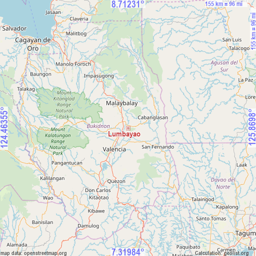
Lumbayao GPS coordinates[2]
8° 1' 0.012" North, 125° 10' 0.012" East
| Map corner | latitude | longitude |
|---|---|---|
| Upper-left | 8.71231°, | 124.46355° |
| Center: | 8.01667°, | 125.16667° |
| Lower-right: | 7.31984°, | 125.8698° |
| Map W x H: | 154.8×154.8 km | = 96.2×96.2mi |
| max Lat: | 20.78733° ⇑82.6% North |
| Lumbayao: | 8.01667° |
| min Lat: | ⇓17.4% South 4.65442° |
| min Long | Lumbayao | max Long |
| 117.04868° | 125.16667° | 126.58417° |
| W 89.9%⇐ | ⇒10.1% E |
Elevation
Elevation of Lumbayao is 327 m = 1073 ft, and this is 239.1 m = 784 ft above average elevation for this country.
| Max E: |
2262 m = 7421 ft | 7% |
| Lumbayao | 327 m 1073 ft | |
| Avg. | 87.9 m = 288 ft | |
Min E: |
-2 m = -7 ft | 93% |
See also: Philippines elevation on elevation.city.
Geographical zone
Lumbayao is located in North Torrid zone (between Equator and Tropic of Cancer). Distance of Equator is 891.4 km =553.9 mi to South.| Distance of | km | miles | from Lumbayao |
|---|---|---|---|
| North Pole | 9115.7 | 5664.2 | to North |
| Arctic Circle | 6509.8 | 4045 | to North |
| Tropic Cancer | 1714.5 | 1065.3 | to North |
| Equator | 891.4 | 553.9 | to South |


Nearby cities:
15 places around Lumbayao: (largest is in red/bold)
• Aglayan
5.6 km =3.5 mi,  319°
319°
• Bantuanon
10.6 km =6.6 mi,  269°
269°
• Bugcaon
6.8 km =4.2 mi,  298°
298°
• Cabangahan
3.3 km =2.1 mi,  281°
281°
• Casisang
14.3 km =8.9 mi,  341°
341°
• Imbatug
13.6 km =8.5 mi,  71°
71°
• Kabulohan
12.5 km =7.8 mi,  76°
76°
• Laguitas
9 km =5.6 mi,  333°
333°
• Lantapan
15.4 km =9.6 mi,  262°
262°
• Linabo
4.4 km =2.7 mi, 342°
• Maglamin
11.2 km =7 mi, 69°
• Mailag
6.1 km =3.8 mi,  211°
211°
• Managok
2.8 km =1.7 mi,  60°
60°
• NIA Valencia
14.6 km =9.1 mi, 213°
• San Carlos
11.7 km =7.3 mi,  237°
237°
Sources, notices
• [Note1] Compared only with cities in Philippines existing in our database
• [Src1] Map data: © OpenStreetMap contributors (CC-BY-SA)
• [Src2] Other city data from geonames.org with taken over terms of usage.
• [Src3] Geographical zone / Annual Mean Temperature by Robert A. Rohde @ Wikipedia
