Linabo geodata
Linabo (Northern Mindanao) is a populated place; located in Philippines in Asia/Manila (GMT+8) time zone. With population of 5,849 people, there are 1075 cities with bigger population in this country. Compared to other cities in Philippines, 82.1% of cities are located further ↑North; 89.8% of cities are located further ←West and 93.7% of cities have lower elevation than Linabo. Note1
Administrative division(s):
- Level 1: Northern Mindanao
- Level 2: Province of Bukidnon
- Level 3: City of Malaybalay


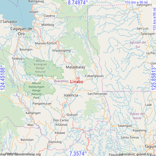
Linabo GPS coordinates[2]
8° 3' 15.012" North, 125° 9' 18" East
| Map corner | latitude | longitude |
|---|---|---|
| Upper-left | 8.74974°, | 124.45188° |
| Center: | 8.05417°, | 125.155° |
| Lower-right: | 7.3574°, | 125.85813° |
| Map W x H: | 154.8×154.8 km | = 96.2×96.2mi |
| max Lat: | 20.78733° ⇑82.1% North |
| Linabo: | 8.05417° |
| min Lat: | ⇓17.9% South 4.65442° |
| min Long | Linabo | max Long |
| 117.04868° | 125.155° | 126.58417° |
| W 89.8%⇐ | ⇒10.2% E |
Elevation
Elevation of Linabo is 359 m = 1178 ft, and this is 271.1 m = 889 ft above average elevation for this country.
| Max E: |
2262 m = 7421 ft | 6.3% |
| Linabo | 359 m 1178 ft | |
| Avg. | 87.9 m = 288 ft | |
Min E: |
-2 m = -7 ft | 93.7% |
See also: Philippines elevation on elevation.city.
Geographical zone
Linabo is located in North Torrid zone (between Equator and Tropic of Cancer). Distance of Equator is 895.5 km =556.4 mi to South.| Distance of | km | miles | from Linabo |
|---|---|---|---|
| North Pole | 9111.5 | 5661.6 | to North |
| Arctic Circle | 6505.6 | 4042.4 | to North |
| Tropic Cancer | 1710.4 | 1062.8 | to North |
| Equator | 895.5 | 556.4 | to South |


Nearby cities:
15 places around Linabo: (largest is in red/bold)
• Aglayan
2.3 km =1.4 mi,  272°
272°
• Bantuanon
10.2 km =6.3 mi,  244°
244°
• Bugcaon
4.7 km =2.9 mi,  258°
258°
• Cabangahan
4 km =2.5 mi,  208°
208°
• Casisang
9.9 km =6.2 mi,  340°
340°
• Imbatug
14.2 km =8.8 mi,  89°
89°
• Kabulohan
13.4 km =8.3 mi,  95°
95°
• Laguitas
4.7 km =2.9 mi,  325°
325°
• Lumbayao
4.4 km =2.7 mi,  162°
162°
• Maglamin
11.7 km =7.3 mi, 91°
• Mailag
9.5 km =5.9 mi,  191°
191°
• Malaybalay
11.9 km =7.4 mi,  345°
345°
• Managok
4.6 km =2.9 mi,  127°
127°
• San Carlos
13.5 km =8.4 mi,  219°
219°
• Sumpong
12.8 km =8 mi, 341°
Sources, notices
• [Note1] Compared only with cities in Philippines existing in our database
• [Src1] Map data: © OpenStreetMap contributors (CC-BY-SA)
• [Src2] Other city data from geonames.org with taken over terms of usage.
• [Src3] Geographical zone / Annual Mean Temperature by Robert A. Rohde @ Wikipedia
