San Gregorio geodata
San Gregorio (Calabarzon) is a populated place; located in Philippines in Asia/Manila (GMT+8) time zone. With population of 3,068 people, there are 2449 cities with bigger population in this country. Compared to other cities in Philippines, 69.4% of cities are located further ↓South; 70.7% of cities are located further →East and 83.1% of cities have lower elevation than San Gregorio. Note1


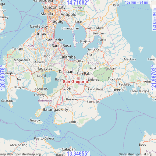
San Gregorio GPS coordinates[2]
14° 1' 46.92" North, 121° 15' 50.04" East
| Map corner | latitude | longitude |
|---|---|---|
| Upper-left | 14.71082°, | 120.56078° |
| Center: | 14.0297°, | 121.2639° |
| Lower-right: | 13.34655°, | 121.96703° |
| Map W x H: | 151.7×151.7 km | = 94.3×94.3mi |
| max Lat: | 20.78733° ⇑30.6% North |
| San Gregorio: | 14.0297° |
| min Lat: | ⇓69.4% South 4.65442° |
| min Long | San Gregorio | max Long |
| 117.04868° | 121.2639° | 126.58417° |
| W 29.3%⇐ | ⇒70.7% E |
Elevation
Elevation of San Gregorio is 117 m = 384 ft, and this is 29.1 m = 95 ft above average elevation for this country.
| Max E: |
2262 m = 7421 ft | 16.9% |
| San Gregorio | 117 m 384 ft | |
| Avg. | 87.9 m = 288 ft | |
Min E: |
-2 m = -7 ft | 83.1% |
See also: Philippines elevation on elevation.city.
Geographical zone
San Gregorio is located in North Torrid zone (between Equator and Tropic of Cancer). Distance of this Northern Tropic circle is 1046 km =650 mi to North.| Distance of | km | miles | from San Gregorio |
|---|---|---|---|
| North Pole | 8447.1 | 5248.8 | to North |
| Arctic Circle | 5841.2 | 3629.6 | to North |
| Tropic Cancer | 1046 | 650 | to North |
| Equator | 1560 | 969.3 | to South |


Nearby cities:
15 places around San Gregorio: (largest is in red/bold)
• Alaminos
4.2 km =2.6 mi,  333°
333°
• Ayusan Uno
9.4 km =5.8 mi,  150°
150°
• Bautista
4.2 km =2.6 mi,  159°
159°
• Lalig
8.5 km =5.3 mi,  127°
127°
• Quipot
10.2 km =6.3 mi,  144°
144°
• San Andres
5.6 km =3.5 mi,  293°
293°
• San Joaquin
5.2 km =3.2 mi, 291°
• San Juan
4.8 km =3 mi,  309°
309°
• San Pablo
7.9 km =4.9 mi,  57°
57°
• Santa Cruz
9.9 km =6.2 mi,  12°
12°
• Santa Cruz
10.1 km =6.3 mi,  95°
95°
• Santiago
1.9 km =1.2 mi,  120°
120°
• Santisimo Rosario
6.1 km =3.8 mi, 126°
• Talisay
9.1 km =5.7 mi,  223°
223°
• Tiaong
9.6 km =6 mi, 139°
Sources, notices
• [Note1] Compared only with cities in Philippines existing in our database
• [Src1] Map data: © OpenStreetMap contributors (CC-BY-SA)
• [Src2] Other city data from geonames.org with taken over terms of usage.
• [Src3] Geographical zone / Annual Mean Temperature by Robert A. Rohde @ Wikipedia
