Alaminos geodata
Alaminos (Calabarzon) is a seat of a third-order administrative division; located in Philippines in Asia/Manila (GMT+8) time zone. With population of 31,427 people, there are 265 cities with bigger population in this country. Compared to other cities in Philippines, 69.9% of cities are located further ↓South; 70.9% of cities are located further →East and 86.1% of cities have lower elevation than Alaminos. Note1


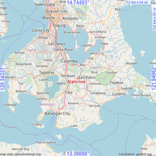
Alaminos GPS coordinates[2]
14° 3' 50.076" North, 121° 14' 47.364" East
| Map corner | latitude | longitude |
|---|---|---|
| Upper-left | 14.74493°, | 120.54337° |
| Center: | 14.06391°, | 121.24649° |
| Lower-right: | 13.38086°, | 121.94962° |
| Map W x H: | 151.7×151.7 km | = 94.3×94.3mi |
| max Lat: | 20.78733° ⇑30.1% North |
| Alaminos: | 14.06391° |
| min Lat: | ⇓69.9% South 4.65442° |
| min Long | Alaminos | max Long |
| 117.04868° | 121.24649° | 126.58417° |
| W 29.1%⇐ | ⇒70.9% E |
Elevation
Elevation of Alaminos is 152 m = 499 ft, and this is 64.1 m = 210 ft above average elevation for this country.
| Max E: |
2262 m = 7421 ft | 13.9% |
| Alaminos | 152 m 499 ft | |
| Avg. | 87.9 m = 288 ft | |
Min E: |
-2 m = -7 ft | 86.1% |
See also: Philippines elevation on elevation.city.
Geographical zone
Alaminos is located in North Torrid zone (between Equator and Tropic of Cancer). Distance of this Northern Tropic circle is 1042.2 km =647.6 mi to North.| Distance of | km | miles | from Alaminos |
|---|---|---|---|
| North Pole | 8443.3 | 5246.4 | to North |
| Arctic Circle | 5837.4 | 3627.2 | to North |
| Tropic Cancer | 1042.2 | 647.6 | to North |
| Equator | 1563.8 | 971.7 | to South |


Nearby cities:
15 places around Alaminos: (largest is in red/bold)
• Bautista
8.4 km =5.2 mi,  156°
156°
• Bitin
6.4 km =4 mi,  335°
335°
• Malvar
9.7 km =6 mi,  257°
257°
• Masaya
10.5 km =6.5 mi,  21°
21°
• San Andres
3.6 km =2.2 mi,  244°
244°
• San Gregorio
4.2 km =2.6 mi,  153°
153°
• San Joaquin
3.5 km =2.2 mi, 237°
• San Juan
2 km =1.2 mi,  247°
247°
• San Pablo
8.5 km =5.3 mi,  86°
86°
• San Pedro One
11 km =6.8 mi, 263°
• Santa Cruz
7.1 km =4.4 mi,  34°
34°
• Santiago
5.9 km =3.7 mi,  143°
143°
• Santisimo Rosario
10.1 km =6.3 mi, 137°
• Talisay
11.3 km =7 mi,  203°
203°
• Tanauan
10.7 km =6.6 mi,  283°
283°
Sources, notices
• [Note1] Compared only with cities in Philippines existing in our database
• [Src1] Map data: © OpenStreetMap contributors (CC-BY-SA)
• [Src2] Other city data from geonames.org with taken over terms of usage.
• [Src3] Geographical zone / Annual Mean Temperature by Robert A. Rohde @ Wikipedia
