Sagasa geodata
Sagasa (Autonomous Region in Muslim Mindanao) is a populated place; located in Philippines in Asia/Manila (GMT+8) time zone. With population of 3,379 people, there are 2159 cities with bigger population in this country. Compared to other cities in Philippines, 93.3% of cities are located further ↑North; 80.3% of cities are located further ←West and 58.8% of cities have lower elevation than Sagasa. Note1
Administrative division(s):
- Level 1: Autonomous Region in Muslim Mindanao
- Level 2: Province of Maguindanao


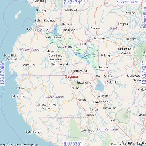
Sagasa GPS coordinates[2]
6° 46' 26.58" North, 124° 34' 26.688" East
| Map corner | latitude | longitude |
|---|---|---|
| Upper-left | 7.47174°, | 123.87096° |
| Center: | 6.77405°, | 124.57408° |
| Lower-right: | 6.07535°, | 125.27721° |
| Map W x H: | 155.3×155.3 km | = 96.5×96.5mi |
| max Lat: | 20.78733° ⇑93.3% North |
| Sagasa: | 6.77405° |
| min Lat: | ⇓6.7% South 4.65442° |
| min Long | Sagasa | max Long |
| 117.04868° | 124.57408° | 126.58417° |
| W 80.3%⇐ | ⇒19.7% E |
Elevation
Elevation of Sagasa is 32 m = 105 ft, and this is 55.9 m = 183 ft below average elevation for this country.
| Max E: |
2262 m = 7421 ft | 41.2% |
| Avg. | 87.9 m = 288 ft | |
| Sagasa | 32 m = 105 ft | |
Min E: |
-2 m = -7 ft | 58.8% |
See also: Philippines elevation on elevation.city.
Geographical zone
Sagasa is located in North Torrid zone (between Equator and Tropic of Cancer). Distance of Equator is 753.2 km =468 mi to South.| Distance of | km | miles | from Sagasa |
|---|---|---|---|
| North Pole | 9253.9 | 5750.1 | to North |
| Arctic Circle | 6648 | 4130.9 | to North |
| Tropic Cancer | 1852.7 | 1151.2 | to North |
| Equator | 753.2 | 468 | to South |


Nearby cities:
15 places around Sagasa: (largest is in red/bold)
• Dukay
12.1 km =7.5 mi,  189°
189°
• Esperanza
8.3 km =5.2 mi,  226°
226°
• Gansing
10.7 km =6.6 mi,  125°
125°
• Kapingkong
12.4 km =7.7 mi,  152°
152°
• Kauran
11.7 km =7.3 mi,  281°
281°
• Laguilayan
12.6 km =7.8 mi,  205°
205°
• Mamali
8.1 km =5 mi,  90°
90°
• Mariano Marcos
11.2 km =7 mi,  113°
113°
• Matiompong
8.7 km =5.4 mi, 185°
• New Lagao
10.9 km =6.8 mi,  136°
136°
• New Panay
3.9 km =2.4 mi,  204°
204°
• Sadsalan
7.2 km =4.5 mi,  32°
32°
• Sampao
11.7 km =7.3 mi,  11°
11°
• Tambak
7.7 km =4.8 mi, 134°
• Villamor
9.8 km =6.1 mi,  217°
217°
Sources, notices
• [Note1] Compared only with cities in Philippines existing in our database
• [Src1] Map data: © OpenStreetMap contributors (CC-BY-SA)
• [Src2] Other city data from geonames.org with taken over terms of usage.
• [Src3] Geographical zone / Annual Mean Temperature by Robert A. Rohde @ Wikipedia
