Sabang Indan geodata
Sabang Indan (Bicol) is a populated place; located in Philippines in Asia/Manila (GMT+8) time zone. With population of 2,803 people, there are 2786 cities with bigger population in this country. Compared to other cities in Philippines, 72.2% of cities are located further ↓South; 51.8% of cities are located further ←West and 99.6% of cities have higher elevation than Sabang Indan. Note1


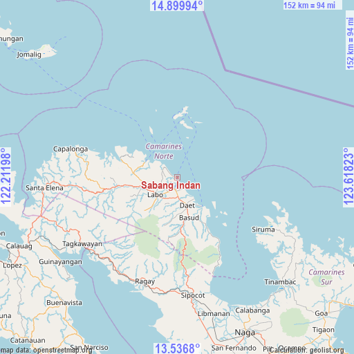
Sabang Indan GPS coordinates[2]
14° 13' 9.84" North, 122° 54' 54.36" East
| Map corner | latitude | longitude |
|---|---|---|
| Upper-left | 14.89994°, | 122.21198° |
| Center: | 14.2194°, | 122.9151° |
| Lower-right: | 13.5368°, | 123.61823° |
| Map W x H: | 151.6×151.6 km | = 94.2×94.2mi |
| max Lat: | 20.78733° ⇑27.8% North |
| Sabang Indan: | 14.2194° |
| min Lat: | ⇓72.2% South 4.65442° |
| min Long | Sabang Indan | max Long |
| 117.04868° | 122.9151° | 126.58417° |
| W 51.8%⇐ | ⇒48.2% E |
Elevation
Elevation of Sabang Indan is 1 m = 3 ft, and this is 86.9 m = 285 ft below average elevation for this country.
| Max E: |
2262 m = 7421 ft | 99.6% |
| Avg. | 87.9 m = 288 ft | |
| Sabang Indan | 1 m = 3 ft | |
Min E: |
-2 m = -7 ft | 0.4% |
See also: Philippines elevation on elevation.city.
Geographical zone
Sabang Indan is located in North Torrid zone (between Equator and Tropic of Cancer). Distance of this Northern Tropic circle is 1024.9 km =636.8 mi to North.| Distance of | km | miles | from Sabang Indan |
|---|---|---|---|
| North Pole | 8426 | 5235.7 | to North |
| Arctic Circle | 5820.1 | 3616.4 | to North |
| Tropic Cancer | 1024.9 | 636.8 | to North |
| Equator | 1581 | 982.4 | to South |


Nearby cities:
15 places around Sabang Indan: (largest is in red/bold)
• Calasgasan
15.3 km =9.5 mi,  172°
172°
• Daet
12.7 km =7.9 mi,  160°
160°
• Dugongan
13 km =8.1 mi,  184°
184°
• Guinacotan
8.6 km =5.3 mi,  216°
216°
• Labo
11.7 km =7.3 mi,  231°
231°
• Lugui
17.7 km =11 mi, 227°
• Malasugui
11.1 km =6.9 mi, 221°
• Matnog
17.1 km =10.6 mi, 173°
• Mercedes
16 km =9.9 mi,  139°
139°
• Paracale
15.3 km =9.5 mi,  296°
296°
• San Vicente
13.4 km =8.3 mi,  199°
199°
• Santo Domingo
9.9 km =6.2 mi, 196°
• Talisay
9.5 km =5.9 mi, 175°
• Talubatib
14.6 km =9.1 mi,  253°
253°
• Vinzons
5.2 km =3.2 mi,  190°
190°
Sources, notices
• [Note1] Compared only with cities in Philippines existing in our database
• [Src1] Map data: © OpenStreetMap contributors (CC-BY-SA)
• [Src2] Other city data from geonames.org with taken over terms of usage.
• [Src3] Geographical zone / Annual Mean Temperature by Robert A. Rohde @ Wikipedia
