Paracale geodata
Paracale (Bicol) is a seat of a third-order administrative division; located in Philippines in Asia/Manila (GMT+8) time zone. With population of 8,290 people, there are 747 cities with bigger population in this country. Compared to other cities in Philippines, 72.7% of cities are located further ↓South; 50.3% of cities are located further →East and 95.5% of cities have higher elevation than Paracale. Note1


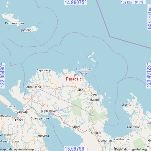
Paracale GPS coordinates[2]
14° 16' 49.44" North, 122° 47' 17.16" East
| Map corner | latitude | longitude |
|---|---|---|
| Upper-left | 14.96075°, | 122.08498° |
| Center: | 14.2804°, | 122.7881° |
| Lower-right: | 13.59799°, | 123.49123° |
| Map W x H: | 151.5×151.5 km | = 94.1×94.1mi |
| max Lat: | 20.78733° ⇑27.3% North |
| Paracale: | 14.2804° |
| min Lat: | ⇓72.7% South 4.65442° |
| min Long | Paracale | max Long |
| 117.04868° | 122.7881° | 126.58417° |
| W 49.7%⇐ | ⇒50.3% E |
Elevation
Elevation of Paracale is 5 m = 16 ft, and this is 82.9 m = 272 ft below average elevation for this country.
| Max E: |
2262 m = 7421 ft | 95.5% |
| Avg. | 87.9 m = 288 ft | |
| Paracale | 5 m = 16 ft | |
Min E: |
-2 m = -7 ft | 4.5% |
See also: Philippines elevation on elevation.city.
Geographical zone
Paracale is located in North Torrid zone (between Equator and Tropic of Cancer). Distance of this Northern Tropic circle is 1018.1 km =632.6 mi to North.| Distance of | km | miles | from Paracale |
|---|---|---|---|
| North Pole | 8419.2 | 5231.4 | to North |
| Arctic Circle | 5813.3 | 3612.2 | to North |
| Tropic Cancer | 1018.1 | 632.6 | to North |
| Equator | 1587.8 | 986.6 | to South |


Nearby cities:
15 places around Paracale: (largest is in red/bold)
• Batobalane
6.7 km =4.2 mi,  218°
218°
• Daguit
12.1 km =7.5 mi,  213°
213°
• Guinacotan
16.2 km =10.1 mi,  147°
147°
• Gumaus
7.8 km =4.8 mi,  295°
295°
• Jose Pañganiban
10.4 km =6.5 mi,  276°
276°
• Labo
14.9 km =9.3 mi,  162°
162°
• Larap
15 km =9.3 mi, 277°
• Lugui
18.6 km =11.6 mi,  178°
178°
• Luklukan
9.6 km =6 mi, 301°
• Malasugui
16.5 km =10.3 mi, 157°
• Sabang Indan
15.3 km =9.5 mi,  116°
116°
• Santa Rosa Sur
7.4 km =4.6 mi,  251°
251°
• Talubatib
10.9 km =6.8 mi, 181°
• Tugos
4.4 km =2.7 mi, 249°
• Vinzons
17.4 km =10.8 mi,  132°
132°
Sources, notices
• [Note1] Compared only with cities in Philippines existing in our database
• [Src1] Map data: © OpenStreetMap contributors (CC-BY-SA)
• [Src2] Other city data from geonames.org with taken over terms of usage.
• [Src3] Geographical zone / Annual Mean Temperature by Robert A. Rohde @ Wikipedia
