Guinacotan geodata
Guinacotan (Bicol) is a populated place; located in Philippines in Asia/Manila (GMT+8) time zone. With population of 2,861 people, there are 2691 cities with bigger population in this country. Compared to other cities in Philippines, 71.2% of cities are located further ↓South; 51% of cities are located further ←West and 76.6% of cities have higher elevation than Guinacotan. Note1


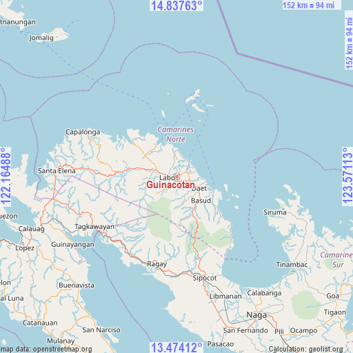
Guinacotan GPS coordinates[2]
14° 9' 24.84" North, 122° 52' 4.8" East
| Map corner | latitude | longitude |
|---|---|---|
| Upper-left | 14.83763°, | 122.16488° |
| Center: | 14.1569°, | 122.868° |
| Lower-right: | 13.47412°, | 123.57113° |
| Map W x H: | 151.6×151.6 km | = 94.2×94.2mi |
| max Lat: | 20.78733° ⇑28.8% North |
| Guinacotan: | 14.1569° |
| min Lat: | ⇓71.2% South 4.65442° |
| min Long | Guinacotan | max Long |
| 117.04868° | 122.868° | 126.58417° |
| W 51%⇐ | ⇒49% E |
Elevation
Elevation of Guinacotan is 10 m = 33 ft, and this is 77.9 m = 256 ft below average elevation for this country.
| Max E: |
2262 m = 7421 ft | 76.6% |
| Avg. | 87.9 m = 288 ft | |
| Guinacotan | 10 m = 33 ft | |
Min E: |
-2 m = -7 ft | 23.4% |
See also: Philippines elevation on elevation.city.
Geographical zone
Guinacotan is located in North Torrid zone (between Equator and Tropic of Cancer). Distance of this Northern Tropic circle is 1031.8 km =641.1 mi to North.| Distance of | km | miles | from Guinacotan |
|---|---|---|---|
| North Pole | 8433 | 5240 | to North |
| Arctic Circle | 5827.1 | 3620.8 | to North |
| Tropic Cancer | 1031.8 | 641.1 | to North |
| Equator | 1574.1 | 978.1 | to South |


Nearby cities:
15 places around Guinacotan: (largest is in red/bold)
• Calasgasan
10.8 km =6.7 mi,  139°
139°
• Daet
10.6 km =6.6 mi,  117°
117°
• Dugongan
7.3 km =4.5 mi,  145°
145°
• Labo
4.1 km =2.5 mi,  264°
264°
• Lugui
9.4 km =5.8 mi,  238°
238°
• Malasugui
2.7 km =1.7 mi, 237°
• Mampurog
12.5 km =7.8 mi,  172°
172°
• Matnog
12.3 km =7.6 mi, 144°
• Sabang Indan
8.6 km =5.3 mi,  36°
36°
• San Vicente
5.7 km =3.5 mi, 174°
• Santo Domingo
3.4 km =2.1 mi, 139°
• Talisay
6.4 km =4 mi,  113°
113°
• Talubatib
9.4 km =5.8 mi,  287°
287°
• Tulay na Lupa
11.3 km =7 mi,  231°
231°
• Vinzons
4.6 km =2.9 mi,  65°
65°
Sources, notices
• [Note1] Compared only with cities in Philippines existing in our database
• [Src1] Map data: © OpenStreetMap contributors (CC-BY-SA)
• [Src2] Other city data from geonames.org with taken over terms of usage.
• [Src3] Geographical zone / Annual Mean Temperature by Robert A. Rohde @ Wikipedia
