Rosales geodata
Rosales (Ilocos) is a seat of a third-order administrative division; located in Philippines in Asia/Manila (GMT+8) time zone. With population of 13,105 people, there are 490 cities with bigger population in this country. Compared to other cities in Philippines, 86% of cities are located further ↓South; 87.1% of cities are located further →East and 62.2% of cities have lower elevation than Rosales. Note1


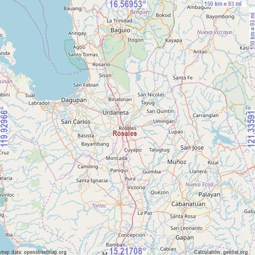
Rosales GPS coordinates[2]
15° 53' 39.984" North, 120° 37' 58.008" East
| Map corner | latitude | longitude |
|---|---|---|
| Upper-left | 16.56953°, | 119.92966° |
| Center: | 15.89444°, | 120.63278° |
| Lower-right: | 15.21708°, | 121.33591° |
| Map W x H: | 150.4×150.4 km | = 93.5×93.5mi |
| max Lat: | 20.78733° ⇑14% North |
| Rosales: | 15.89444° |
| min Lat: | ⇓86% South 4.65442° |
| min Long | Rosales | max Long |
| 117.04868° | 120.63278° | 126.58417° |
| W 12.9%⇐ | ⇒87.1% E |
Elevation
Elevation of Rosales is 37 m = 121 ft, and this is 50.9 m = 167 ft below average elevation for this country.
| Max E: |
2262 m = 7421 ft | 37.8% |
| Avg. | 87.9 m = 288 ft | |
| Rosales | 37 m = 121 ft | |
Min E: |
-2 m = -7 ft | 62.2% |
See also: Philippines elevation on elevation.city.
Geographical zone
Rosales is located in North Torrid zone (between Equator and Tropic of Cancer). Distance of this Northern Tropic circle is 838.6 km =521.1 mi to North.| Distance of | km | miles | from Rosales |
|---|---|---|---|
| North Pole | 8239.8 | 5120 | to North |
| Arctic Circle | 5633.9 | 3500.7 | to North |
| Tropic Cancer | 838.6 | 521.1 | to North |
| Equator | 1767.3 | 1098.1 | to South |


Nearby cities:
15 places around Rosales: (largest is in red/bold)
• Bacag
6.7 km =4.2 mi,  306°
306°
• Balungao
6 km =3.7 mi,  86°
86°
• Barangobong
9.2 km =5.7 mi,  258°
258°
• Bued
6.7 km =4.2 mi,  163°
163°
• Caramutan
3.8 km =2.4 mi,  320°
320°
• Carmen
3.6 km =2.2 mi, 255°
• Carusucan
8 km =5 mi,  2°
2°
• Gueset
6.2 km =3.9 mi, 0°
• Guiling
6 km =3.7 mi,  198°
198°
• Puelay
6.4 km =4 mi, 262°
• Salcedo
5.4 km =3.4 mi,  220°
220°
• Samon
4.9 km =3 mi,  23°
23°
• San Felipe
8.5 km =5.3 mi,  206°
206°
• Tombod
8.1 km =5 mi,  300°
300°
• Villasis
4.8 km =3 mi,  279°
279°
Sources, notices
• [Note1] Compared only with cities in Philippines existing in our database
• [Src1] Map data: © OpenStreetMap contributors (CC-BY-SA)
• [Src2] Other city data from geonames.org with taken over terms of usage.
• [Src3] Geographical zone / Annual Mean Temperature by Robert A. Rohde @ Wikipedia
