Salcedo geodata
Salcedo (Central Luzon) is a populated place; located in Philippines in Asia/Manila (GMT+8) time zone. With population of 2,182 people, there are 3920 cities with bigger population in this country. Compared to other cities in Philippines, 85.6% of cities are located further ↓South; 88% of cities are located further →East and 54.4% of cities have lower elevation than Salcedo. Note1


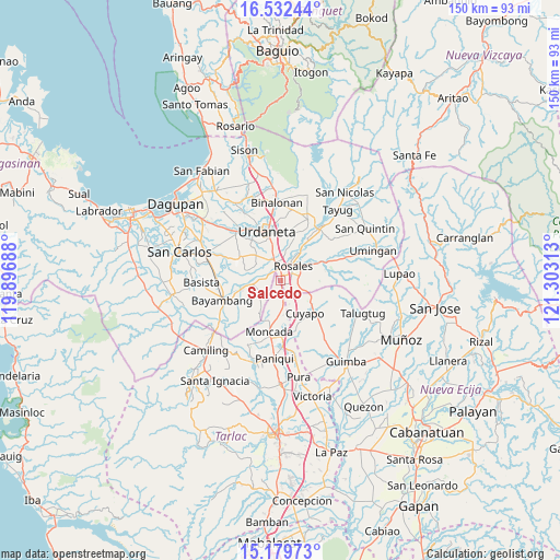
Salcedo GPS coordinates[2]
15° 51' 25.992" North, 120° 36' 0" East
| Map corner | latitude | longitude |
|---|---|---|
| Upper-left | 16.53244°, | 119.89688° |
| Center: | 15.85722°, | 120.6° |
| Lower-right: | 15.17973°, | 121.30313° |
| Map W x H: | 150.4×150.4 km | = 93.5×93.5mi |
| max Lat: | 20.78733° ⇑14.4% North |
| Salcedo: | 15.85722° |
| min Lat: | ⇓85.6% South 4.65442° |
| min Long | Salcedo | max Long |
| 117.04868° | 120.6° | 126.58417° |
| W 12%⇐ | ⇒88% E |
Elevation
Elevation of Salcedo is 27 m = 89 ft, and this is 60.9 m = 200 ft below average elevation for this country.
| Max E: |
2262 m = 7421 ft | 45.6% |
| Avg. | 87.9 m = 288 ft | |
| Salcedo | 27 m = 89 ft | |
Min E: |
-2 m = -7 ft | 54.4% |
See also: Philippines elevation on elevation.city.
Geographical zone
Salcedo is located in North Torrid zone (between Equator and Tropic of Cancer). Distance of this Northern Tropic circle is 842.8 km =523.7 mi to North.| Distance of | km | miles | from Salcedo |
|---|---|---|---|
| North Pole | 8243.9 | 5122.5 | to North |
| Arctic Circle | 5638 | 3503.3 | to North |
| Tropic Cancer | 842.8 | 523.7 | to North |
| Equator | 1763.2 | 1095.6 | to South |


Nearby cities:
15 places around Salcedo: (largest is in red/bold)
• Alcala
8.2 km =5.1 mi,  262°
262°
• Barangobong
6 km =3.7 mi,  292°
292°
• Bued
5.8 km =3.6 mi,  113°
113°
• Calancuasan Norte
7.6 km =4.7 mi,  144°
144°
• Caramutan
7.1 km =4.4 mi,  8°
8°
• Carmen
3.2 km =2 mi,  359°
359°
• Guiling
2.3 km =1.4 mi,  134°
134°
• Lanat
7.3 km =4.5 mi,  176°
176°
• Pindangan Centro
5.2 km =3.2 mi,  274°
274°
• Puelay
4.3 km =2.7 mi,  319°
319°
• Rosales
5.4 km =3.4 mi,  40°
40°
• San Felipe
3.5 km =2.2 mi, 184°
• San Manuel
6.5 km =4 mi,  171°
171°
• San Pedro Apartado
4.3 km =2.7 mi,  238°
238°
• Villasis
5.1 km =3.2 mi,  345°
345°
Sources, notices
• [Note1] Compared only with cities in Philippines existing in our database
• [Src1] Map data: © OpenStreetMap contributors (CC-BY-SA)
• [Src2] Other city data from geonames.org with taken over terms of usage.
• [Src3] Geographical zone / Annual Mean Temperature by Robert A. Rohde @ Wikipedia
