Barangobong geodata
Barangobong (Ilocos) is a populated place; located in Philippines in Asia/Manila (GMT+8) time zone. With population of 3,644 people, there are 1951 cities with bigger population in this country. Compared to other cities in Philippines, 85.8% of cities are located further ↓South; 89.6% of cities are located further →East and 57.4% of cities have lower elevation than Barangobong. Note1


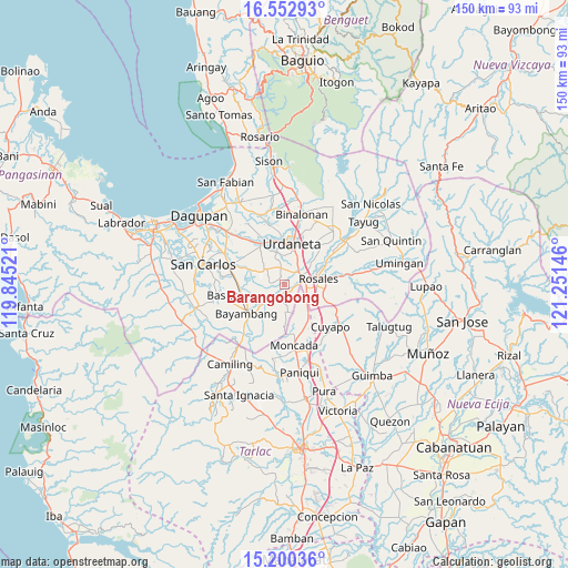
Barangobong GPS coordinates[2]
15° 52' 40.008" North, 120° 32' 53.988" East
| Map corner | latitude | longitude |
|---|---|---|
| Upper-left | 16.55293°, | 119.84521° |
| Center: | 15.87778°, | 120.54833° |
| Lower-right: | 15.20036°, | 121.25146° |
| Map W x H: | 150.4×150.4 km | = 93.5×93.5mi |
| max Lat: | 20.78733° ⇑14.2% North |
| Barangobong: | 15.87778° |
| min Lat: | ⇓85.8% South 4.65442° |
| min Long | Barangobong | max Long |
| 117.04868° | 120.54833° | 126.58417° |
| W 10.4%⇐ | ⇒89.6% E |
Elevation
Elevation of Barangobong is 30 m = 98 ft, and this is 57.9 m = 190 ft below average elevation for this country.
| Max E: |
2262 m = 7421 ft | 42.6% |
| Avg. | 87.9 m = 288 ft | |
| Barangobong | 30 m = 98 ft | |
Min E: |
-2 m = -7 ft | 57.4% |
See also: Philippines elevation on elevation.city.
Geographical zone
Barangobong is located in North Torrid zone (between Equator and Tropic of Cancer). Distance of this Northern Tropic circle is 840.5 km =522.3 mi to North.| Distance of | km | miles | from Barangobong |
|---|---|---|---|
| North Pole | 8241.6 | 5121.1 | to North |
| Arctic Circle | 5635.7 | 3501.9 | to North |
| Tropic Cancer | 840.5 | 522.3 | to North |
| Equator | 1765.4 | 1097 | to South |


Nearby cities:
15 places around Barangobong: (largest is in red/bold)
• Alcala
4.3 km =2.7 mi,  217°
217°
• Bacag
6.8 km =4.2 mi,  31°
31°
• Buenlag
6.6 km =4.1 mi, 216°
• Capulaan
3.2 km =2 mi,  338°
338°
• Carmen
5.6 km =3.5 mi,  80°
80°
• Olea
6.1 km =3.8 mi,  253°
253°
• Pindangan Centro
1.9 km =1.2 mi,  170°
170°
• Puelay
2.9 km =1.8 mi,  69°
69°
• Salcedo
6 km =3.7 mi,  112°
112°
• San Felipe
7.8 km =4.8 mi,  137°
137°
• San Pedro Apartado
4.9 km =3 mi,  158°
158°
• Sanlibo
4.3 km =2.7 mi,  2°
2°
• Tombod
6.3 km =3.9 mi,  18°
18°
• Unzad
4.7 km =2.9 mi,  347°
347°
• Villasis
5 km =3.1 mi,  58°
58°
Sources, notices
• [Note1] Compared only with cities in Philippines existing in our database
• [Src1] Map data: © OpenStreetMap contributors (CC-BY-SA)
• [Src2] Other city data from geonames.org with taken over terms of usage.
• [Src3] Geographical zone / Annual Mean Temperature by Robert A. Rohde @ Wikipedia
