Villasis geodata
Villasis (Ilocos) is a seat of a third-order administrative division; located in Philippines in Asia/Manila (GMT+8) time zone. With population of 13,122 people, there are 488 cities with bigger population in this country. Compared to other cities in Philippines, 86.1% of cities are located further ↓South; 88.5% of cities are located further →East and 57.4% of cities have lower elevation than Villasis. Note1


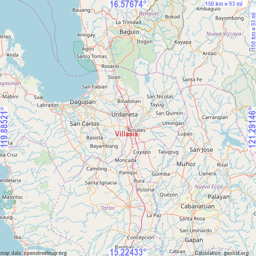
Villasis GPS coordinates[2]
15° 54' 6.012" North, 120° 35' 17.988" East
| Map corner | latitude | longitude |
|---|---|---|
| Upper-left | 16.57674°, | 119.88521° |
| Center: | 15.90167°, | 120.58833° |
| Lower-right: | 15.22433°, | 121.29146° |
| Map W x H: | 150.4×150.4 km | = 93.5×93.5mi |
| max Lat: | 20.78733° ⇑13.9% North |
| Villasis: | 15.90167° |
| min Lat: | ⇓86.1% South 4.65442° |
| min Long | Villasis | max Long |
| 117.04868° | 120.58833° | 126.58417° |
| W 11.5%⇐ | ⇒88.5% E |
Elevation
Elevation of Villasis is 30 m = 98 ft, and this is 57.9 m = 190 ft below average elevation for this country.
| Max E: |
2262 m = 7421 ft | 42.6% |
| Avg. | 87.9 m = 288 ft | |
| Villasis | 30 m = 98 ft | |
Min E: |
-2 m = -7 ft | 57.4% |
See also: Philippines elevation on elevation.city.
Geographical zone
Villasis is located in North Torrid zone (between Equator and Tropic of Cancer). Distance of this Northern Tropic circle is 837.8 km =520.6 mi to North.| Distance of | km | miles | from Villasis |
|---|---|---|---|
| North Pole | 8239 | 5119.5 | to North |
| Arctic Circle | 5633.1 | 3500.2 | to North |
| Tropic Cancer | 837.8 | 520.6 | to North |
| Equator | 1768.1 | 1098.6 | to South |


Nearby cities:
15 places around Villasis: (largest is in red/bold)
• Bacag
3.2 km =2 mi,  348°
348°
• Barangobong
5 km =3.1 mi,  238°
238°
• Capulaan
5.5 km =3.4 mi,  273°
273°
• Caramutan
3.2 km =2 mi,  47°
47°
• Carmen
2.1 km =1.3 mi,  144°
144°
• Gueset
7.2 km =4.5 mi,  41°
41°
• Guiling
7.1 km =4.4 mi,  156°
156°
• Pindangan Centro
6 km =3.7 mi,  220°
220°
• Puelay
2.3 km =1.4 mi, 223°
• Rosales
4.8 km =3 mi,  99°
99°
• Salcedo
5.1 km =3.2 mi,  165°
165°
• Samon
7.6 km =4.7 mi,  60°
60°
• Sanlibo
4.4 km =2.7 mi,  292°
292°
• Tombod
4 km =2.5 mi,  325°
325°
• Unzad
5.6 km =3.5 mi, 290°
Sources, notices
• [Note1] Compared only with cities in Philippines existing in our database
• [Src1] Map data: © OpenStreetMap contributors (CC-BY-SA)
• [Src2] Other city data from geonames.org with taken over terms of usage.
• [Src3] Geographical zone / Annual Mean Temperature by Robert A. Rohde @ Wikipedia
