Butuan geodata
Butuan (Caraga) is a seat of a first-order administrative division; located in Philippines in Asia/Manila (GMT+8) time zone. With population of 309,709 people, there are 27 cities with bigger population in this country. Compared to other cities in Philippines, 76.2% of cities are located further ↑North; 93.9% of cities are located further ←West and 80.7% of cities have higher elevation than Butuan. Note1
Administrative division(s):
- Level 1: Caraga
- Level 2: Province of Agusan del Norte
- Level 3: Butuan City


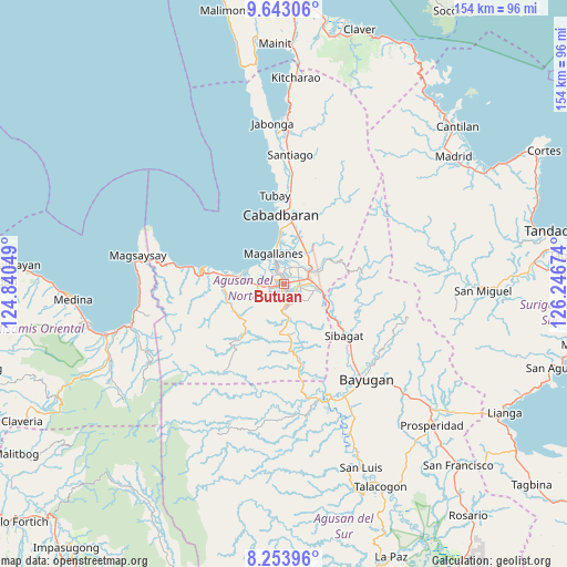
Butuan GPS coordinates[2]
8° 56' 57.012" North, 125° 32' 36.996" East
| Map corner | latitude | longitude |
|---|---|---|
| Upper-left | 9.64306°, | 124.84049° |
| Center: | 8.94917°, | 125.54361° |
| Lower-right: | 8.25396°, | 126.24674° |
| Map W x H: | 154.5×154.5 km | = 96×96mi |
| max Lat: | 20.78733° ⇑76.2% North |
| Butuan: | 8.94917° |
| min Lat: | ⇓23.8% South 4.65442° |
| min Long | Butuan | max Long |
| 117.04868° | 125.54361° | 126.58417° |
| W 93.9%⇐ | ⇒6.1% E |
Elevation
Elevation of Butuan is 9 m = 30 ft, and this is 78.9 m = 259 ft below average elevation for this country.
| Max E: |
2262 m = 7421 ft | 80.7% |
| Avg. | 87.9 m = 288 ft | |
| Butuan | 9 m = 30 ft | |
Min E: |
-2 m = -7 ft | 19.3% |
See also: Butuan elevation on elevation.city.
Geographical zone
Butuan is located in North Torrid zone (between Equator and Tropic of Cancer). Distance of Equator is 995.1 km =618.3 mi to South.| Distance of | km | miles | from Butuan |
|---|---|---|---|
| North Pole | 9012 | 5599.8 | to North |
| Arctic Circle | 6406.1 | 3980.6 | to North |
| Tropic Cancer | 1610.9 | 1001 | to North |
| Equator | 995.1 | 618.3 | to South |


Nearby cities:
15 places around Butuan: (largest is in red/bold)
• Agay
12.5 km =7.8 mi,  22°
22°
• Alubijid
13 km =8.1 mi,  276°
276°
• Anticala
12.7 km =7.9 mi,  61°
61°
• Balangbalang
14.8 km =9.2 mi,  35°
35°
• Bancasi
8.7 km =5.4 mi, 282°
• Basag
9 km =5.6 mi,  107°
107°
• Buenavista
15.1 km =9.4 mi, 281°
• Caloc-an
11 km =6.8 mi,  352°
352°
• Guinabsan
15.1 km =9.4 mi,  247°
247°
• Libertad
4.6 km =2.9 mi,  263°
263°
• Lombocan
7.7 km =4.8 mi,  327°
327°
• Los Angeles
10 km =6.2 mi,  45°
45°
• Magallanes
8.4 km =5.2 mi,  339°
339°
• Manapa
11.9 km =7.4 mi,  285°
285°
• Taligaman
13.3 km =8.3 mi, 111°
Sources, notices
• [Note1] Compared only with cities in Philippines existing in our database
• [Src1] Map data: © OpenStreetMap contributors (CC-BY-SA)
• [Src2] Other city data from geonames.org with taken over terms of usage.
• [Src3] Geographical zone / Annual Mean Temperature by Robert A. Rohde @ Wikipedia
