Rimpeso geodata
Rimpeso (Autonomous Region in Muslim Mindanao) is a populated place; located in Philippines in Asia/Manila (GMT+8) time zone. With population of 3,494 people, there are 2057 cities with bigger population in this country. Compared to other cities in Philippines, 91.5% of cities are located further ↑North; 72.9% of cities are located further ←West and 96% of cities have lower elevation than Rimpeso. Note1
Administrative division(s):
- Level 1: Autonomous Region in Muslim Mindanao
- Level 2: Province of Maguindanao
- Level 3: Upi


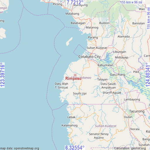
Rimpeso GPS coordinates[2]
7° 1' 26.004" North, 124° 6' 1.008" East
| Map corner | latitude | longitude |
|---|---|---|
| Upper-left | 7.7212°, | 123.39716° |
| Center: | 7.02389°, | 124.10028° |
| Lower-right: | 6.32554°, | 124.80341° |
| Map W x H: | 155.2×155.2 km | = 96.4×96.4mi |
| max Lat: | 20.78733° ⇑91.5% North |
| Rimpeso: | 7.02389° |
| min Lat: | ⇓8.5% South 4.65442° |
| min Long | Rimpeso | max Long |
| 117.04868° | 124.10028° | 126.58417° |
| W 72.9%⇐ | ⇒27.1% E |
Elevation
Elevation of Rimpeso is 507 m = 1663 ft, and this is 419.1 m = 1375 ft above average elevation for this country.
| Max E: |
2262 m = 7421 ft | 4% |
| Rimpeso | 507 m 1663 ft | |
| Avg. | 87.9 m = 288 ft | |
Min E: |
-2 m = -7 ft | 96% |
See also: Philippines elevation on elevation.city.
Geographical zone
Rimpeso is located in North Torrid zone (between Equator and Tropic of Cancer). Distance of Equator is 781 km =485.3 mi to South.| Distance of | km | miles | from Rimpeso |
|---|---|---|---|
| North Pole | 9226.1 | 5732.8 | to North |
| Arctic Circle | 6620.2 | 4113.6 | to North |
| Tropic Cancer | 1824.9 | 1133.9 | to North |
| Equator | 781 | 485.3 | to South |


Nearby cities:
15 places around Rimpeso: (largest is in red/bold)
• Awang
19.6 km =12.2 mi,  42°
42°
• Blinsung
8.9 km =5.5 mi,  94°
94°
• Cotabato
27.4 km =17 mi, 35°
• Dadus
24.7 km =15.3 mi,  81°
81°
• Dinaig
23.7 km =14.7 mi, 89°
• Gadung
26.2 km =16.3 mi,  199°
199°
• Labuñgan
17.3 km =10.7 mi,  59°
59°
• Limbo
29.9 km =18.6 mi,  32°
32°
• Makir
22.5 km =14 mi, 88°
• Salimbao
27.8 km =17.3 mi, 37°
• South Upi
21.9 km =13.6 mi,  165°
165°
• Sultan Kudarat
28.7 km =17.8 mi, 37°
• Tamontaka
22.2 km =13.8 mi, 38°
• Taviran
26.6 km =16.5 mi,  65°
65°
• Upi
7.3 km =4.5 mi, 88°
Sources, notices
• [Note1] Compared only with cities in Philippines existing in our database
• [Src1] Map data: © OpenStreetMap contributors (CC-BY-SA)
• [Src2] Other city data from geonames.org with taken over terms of usage.
• [Src3] Geographical zone / Annual Mean Temperature by Robert A. Rohde @ Wikipedia
