South Upi geodata
South Upi (Autonomous Region in Muslim Mindanao) is a seat of a third-order administrative division; located in Philippines in Asia/Manila (GMT+8) time zone. With population of 12,538 people, there are 504 cities with bigger population in this country. Compared to other cities in Philippines, 93% of cities are located further ↑North; 73.4% of cities are located further ←West and 96.1% of cities have lower elevation than South Upi. Note1
Administrative division(s):
- Level 1: Autonomous Region in Muslim Mindanao
- Level 2: Province of Maguindanao
- Level 3: South Upi


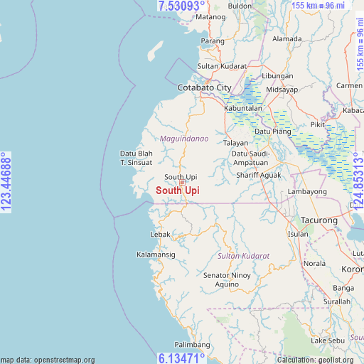
South Upi GPS coordinates[2]
6° 49' 59.988" North, 124° 9' 0" East
| Map corner | latitude | longitude |
|---|---|---|
| Upper-left | 7.53093°, | 123.44688° |
| Center: | 6.83333°, | 124.15° |
| Lower-right: | 6.13471°, | 124.85313° |
| Map W x H: | 155.2×155.2 km | = 96.4×96.4mi |
| max Lat: | 20.78733° ⇑93% North |
| South Upi: | 6.83333° |
| min Lat: | ⇓7% South 4.65442° |
| min Long | South Upi | max Long |
| 117.04868° | 124.15° | 126.58417° |
| W 73.4%⇐ | ⇒26.6% E |
Elevation
Elevation of South Upi is 515 m = 1690 ft, and this is 427.1 m = 1401 ft above average elevation for this country.
| Max E: |
2262 m = 7421 ft | 3.9% |
| South Upi | 515 m 1690 ft | |
| Avg. | 87.9 m = 288 ft | |
Min E: |
-2 m = -7 ft | 96.1% |
See also: Philippines elevation on elevation.city.
Geographical zone
South Upi is located in North Torrid zone (between Equator and Tropic of Cancer). Distance of Equator is 759.8 km =472.1 mi to South.| Distance of | km | miles | from South Upi |
|---|---|---|---|
| North Pole | 9247.3 | 5746 | to North |
| Arctic Circle | 6641.4 | 4126.8 | to North |
| Tropic Cancer | 1846.1 | 1147.1 | to North |
| Equator | 759.8 | 472.1 | to South |


Nearby cities:
15 places around South Upi: (largest is in red/bold)
• Basak
11.8 km =7.3 mi,  179°
179°
• Blinsung
20.8 km =12.9 mi,  9°
9°
• Gadung
14.8 km =9.2 mi,  256°
256°
• Kalamangog
15 km =9.3 mi,  216°
216°
• Lebak
23 km =14.3 mi,  203°
203°
• Makir
27.8 km =17.3 mi,  37°
37°
• Noling
20.1 km =12.5 mi, 196°
• Puloypuloy
22.8 km =14.2 mi, 195°
• Puricay
18.6 km =11.6 mi,  208°
208°
• Ragandang
19.1 km =11.9 mi,  189°
189°
• Rimpeso
21.9 km =13.6 mi,  345°
345°
• Taguisa
19.6 km =12.2 mi, 220°
• Tapikan
19.2 km =11.9 mi,  83°
83°
• Tran
16.4 km =10.2 mi, 219°
• Upi
21.5 km =13.4 mi,  4°
4°
Sources, notices
• [Note1] Compared only with cities in Philippines existing in our database
• [Src1] Map data: © OpenStreetMap contributors (CC-BY-SA)
• [Src2] Other city data from geonames.org with taken over terms of usage.
• [Src3] Geographical zone / Annual Mean Temperature by Robert A. Rohde @ Wikipedia
