Estefania geodata
Estefania (Cagayan Valley) is a populated place; located in Philippines in Asia/Manila (GMT+8) time zone. With population of 2,165 people, there are 3960 cities with bigger population in this country. Compared to other cities in Philippines, 97.8% of cities are located further ↓South; 63.7% of cities are located further →East and 56.1% of cities have higher elevation than Estefania. Note1


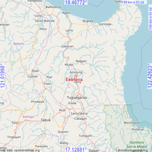
Estefania GPS coordinates[2]
17° 47' 58.272" North, 121° 43' 23.16" East
| Map corner | latitude | longitude |
|---|---|---|
| Upper-left | 18.46772°, | 121.01998° |
| Center: | 17.79952°, | 121.7231° |
| Lower-right: | 17.12881°, | 122.42623° |
| Map W x H: | 148.9×148.9 km | = 92.5×92.5mi |
| max Lat: | 20.78733° ⇑2.2% North |
| Estefania: | 17.79952° |
| min Lat: | ⇓97.8% South 4.65442° |
| min Long | Estefania | max Long |
| 117.04868° | 121.7231° | 126.58417° |
| W 36.3%⇐ | ⇒63.7% E |
Elevation
Elevation of Estefania is 19 m = 62 ft, and this is 68.9 m = 226 ft below average elevation for this country.
| Max E: |
2262 m = 7421 ft | 56.1% |
| Avg. | 87.9 m = 288 ft | |
| Estefania | 19 m = 62 ft | |
Min E: |
-2 m = -7 ft | 43.9% |
See also: Philippines elevation on elevation.city.
Geographical zone
Estefania is located in North Torrid zone (between Equator and Tropic of Cancer). Distance of this Northern Tropic circle is 626.8 km =389.5 mi to North.| Distance of | km | miles | from Estefania |
|---|---|---|---|
| North Pole | 8027.9 | 4988.3 | to North |
| Arctic Circle | 5422.1 | 3369.1 | to North |
| Tropic Cancer | 626.8 | 389.5 | to North |
| Equator | 1979.1 | 1229.8 | to South |


Nearby cities:
15 places around Estefania: (largest is in red/bold)
• Afusing Centro
11.8 km =7.3 mi,  300°
300°
• Aggugaddah
13.9 km =8.6 mi,  142°
142°
• Alcala
13.4 km =8.3 mi,  328°
328°
• Amulung
4 km =2.5 mi,  0°
0°
• Bauan
9.7 km =6 mi,  207°
207°
• Calantac
12.2 km =7.6 mi,  359°
359°
• Dassun
6.2 km =3.9 mi,  191°
191°
• Gammad
10.1 km =6.3 mi,  167°
167°
• Iguig
5.6 km =3.5 mi, 165°
• Iraga
13.1 km =8.1 mi, 213°
• Lanna
11.8 km =7.3 mi, 191°
• Minanga Norte
4.4 km =2.7 mi, 171°
• Nattapian
14 km =8.7 mi, 188°
• Quibal
13.2 km =8.2 mi,  134°
134°
• Tupang
14.6 km =9.1 mi,  323°
323°
Sources, notices
• [Note1] Compared only with cities in Philippines existing in our database
• [Src1] Map data: © OpenStreetMap contributors (CC-BY-SA)
• [Src2] Other city data from geonames.org with taken over terms of usage.
• [Src3] Geographical zone / Annual Mean Temperature by Robert A. Rohde @ Wikipedia
