Punta Silum geodata
Punta Silum (Northern Mindanao) is a populated place; located in Philippines in Asia/Manila (GMT+8) time zone. With population of 3,613 people, there are 1971 cities with bigger population in this country. Compared to other cities in Philippines, 79.4% of cities are located further ↑North; 74.9% of cities are located further ←West and 56.1% of cities have higher elevation than Punta Silum. Note1


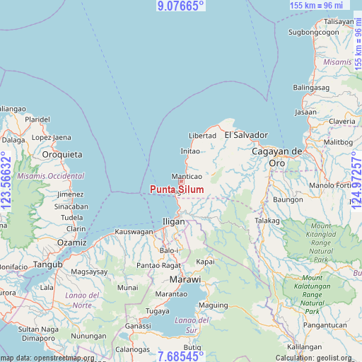
Punta Silum GPS coordinates[2]
8° 22' 54.012" North, 124° 16' 9.984" East
| Map corner | latitude | longitude |
|---|---|---|
| Upper-left | 9.07665°, | 123.56632° |
| Center: | 8.38167°, | 124.26944° |
| Lower-right: | 7.68545°, | 124.97257° |
| Map W x H: | 154.7×154.7 km | = 96.1×96.1mi |
| max Lat: | 20.78733° ⇑79.4% North |
| Punta Silum: | 8.38167° |
| min Lat: | ⇓20.6% South 4.65442° |
| min Long | Punta Silum | max Long |
| 117.04868° | 124.26944° | 126.58417° |
| W 74.9%⇐ | ⇒25.1% E |
Elevation
Elevation of Punta Silum is 19 m = 62 ft, and this is 68.9 m = 226 ft below average elevation for this country.
| Max E: |
2262 m = 7421 ft | 56.1% |
| Avg. | 87.9 m = 288 ft | |
| Punta Silum | 19 m = 62 ft | |
Min E: |
-2 m = -7 ft | 43.9% |
See also: Philippines elevation on elevation.city.
Geographical zone
Punta Silum is located in North Torrid zone (between Equator and Tropic of Cancer). Distance of Equator is 932 km =579.1 mi to South.| Distance of | km | miles | from Punta Silum |
|---|---|---|---|
| North Pole | 9075.1 | 5639 | to North |
| Arctic Circle | 6469.2 | 4019.8 | to North |
| Tropic Cancer | 1674 | 1040.2 | to North |
| Equator | 932 | 579.1 | to South |


Nearby cities:
15 places around Punta Silum: (largest is in red/bold)
• Biga
2.9 km =1.8 mi,  201°
201°
• Buawan
8.1 km =5 mi,  152°
152°
• Dalipuga
7.5 km =4.7 mi,  192°
192°
• Digkilaan
15.4 km =9.6 mi,  160°
160°
• Gimampang
10.4 km =6.5 mi,  16°
16°
• Initao
13.7 km =8.5 mi, 16°
• Kabalantian
6.5 km =4 mi,  100°
100°
• Libertad
15.2 km =9.4 mi, 195°
• Lugait
4.6 km =2.9 mi, 194°
• Manticao
3.1 km =1.9 mi,  37°
37°
• Maputi
7.9 km =4.9 mi, 17°
• Mat-i
8.6 km =5.3 mi,  74°
74°
• Naawan
6.2 km =3.9 mi, 20°
• Sungai
16.6 km =10.3 mi,  62°
62°
• Tuod
10.2 km =6.3 mi,  114°
114°
Sources, notices
• [Note1] Compared only with cities in Philippines existing in our database
• [Src1] Map data: © OpenStreetMap contributors (CC-BY-SA)
• [Src2] Other city data from geonames.org with taken over terms of usage.
• [Src3] Geographical zone / Annual Mean Temperature by Robert A. Rohde @ Wikipedia
