Buawan geodata
Buawan (Soccsksargen) is a populated place; located in Philippines in Asia/Manila (GMT+8) time zone. With population of 2,120 people, there are 4043 cities with bigger population in this country. Compared to other cities in Philippines, 79.9% of cities are located further ↑North; 75.6% of cities are located further ←West and 93.4% of cities have lower elevation than Buawan. Note1


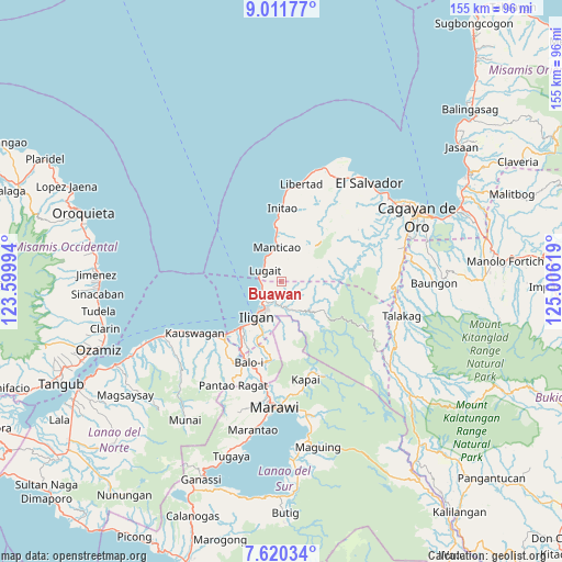
Buawan GPS coordinates[2]
8° 19' 0.012" North, 124° 18' 11.016" East
| Map corner | latitude | longitude |
|---|---|---|
| Upper-left | 9.01177°, | 123.59994° |
| Center: | 8.31667°, | 124.30306° |
| Lower-right: | 7.62034°, | 125.00619° |
| Map W x H: | 154.7×154.7 km | = 96.1×96.1mi |
| max Lat: | 20.78733° ⇑79.9% North |
| Buawan: | 8.31667° |
| min Lat: | ⇓20.1% South 4.65442° |
| min Long | Buawan | max Long |
| 117.04868° | 124.30306° | 126.58417° |
| W 75.6%⇐ | ⇒24.4% E |
Elevation
Elevation of Buawan is 344 m = 1129 ft, and this is 256.1 m = 840 ft above average elevation for this country.
| Max E: |
2262 m = 7421 ft | 6.6% |
| Buawan | 344 m 1129 ft | |
| Avg. | 87.9 m = 288 ft | |
Min E: |
-2 m = -7 ft | 93.4% |
See also: Philippines elevation on elevation.city.
Geographical zone
Buawan is located in North Torrid zone (between Equator and Tropic of Cancer). Distance of Equator is 924.7 km =574.6 mi to South.| Distance of | km | miles | from Buawan |
|---|---|---|---|
| North Pole | 9082.3 | 5643.5 | to North |
| Arctic Circle | 6476.4 | 4024.2 | to North |
| Tropic Cancer | 1681.2 | 1044.6 | to North |
| Equator | 924.7 | 574.6 | to South |


Nearby cities:
15 places around Buawan: (largest is in red/bold)
• Biga
6.6 km =4.1 mi,  313°
313°
• Dalipuga
5.3 km =3.3 mi,  268°
268°
• Digkilaan
7.5 km =4.7 mi,  167°
167°
• Iligan
11.8 km =7.3 mi,  213°
213°
• Iligan City
13 km =8.1 mi,  124°
124°
• Kabalantian
6.6 km =4.1 mi,  24°
24°
• Libertad
10.7 km =6.6 mi,  225°
225°
• Lugait
5.5 km =3.4 mi,  299°
299°
• Manticao
9.9 km =6.2 mi,  349°
349°
• Maputi
14.9 km =9.3 mi, 354°
• Mat-i
10.6 km =6.6 mi,  26°
26°
• Naawan
13.2 km =8.2 mi, 353°
• Punta Silum
8.1 km =5 mi,  332°
332°
• Rogongon
9.8 km =6.1 mi,  160°
160°
• Tuod
6.4 km =4 mi,  62°
62°
Sources, notices
• [Note1] Compared only with cities in Philippines existing in our database
• [Src1] Map data: © OpenStreetMap contributors (CC-BY-SA)
• [Src2] Other city data from geonames.org with taken over terms of usage.
• [Src3] Geographical zone / Annual Mean Temperature by Robert A. Rohde @ Wikipedia
