Tuod geodata
Tuod (Northern Mindanao) is a populated place; located in Philippines in Asia/Manila (GMT+8) time zone. With population of 2,778 people, there are 2824 cities with bigger population in this country. Compared to other cities in Philippines, 79.7% of cities are located further ↑North; 76.6% of cities are located further ←West and 81.8% of cities have lower elevation than Tuod. Note1
Administrative division(s):
- Level 1: Northern Mindanao
- Level 2: Province of Misamis Oriental
- Level 3: Manticao


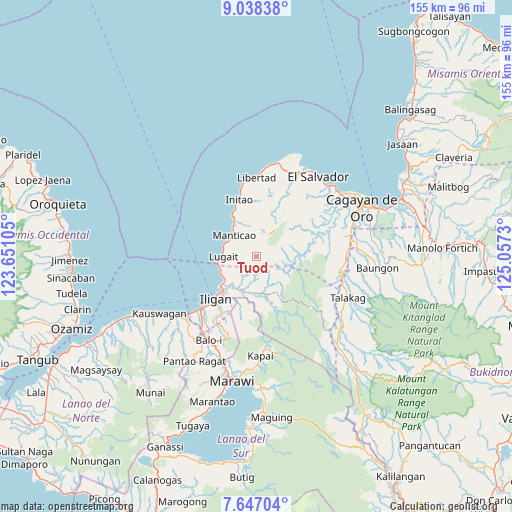
Tuod GPS coordinates[2]
8° 20' 35.988" North, 124° 21' 15.012" East
| Map corner | latitude | longitude |
|---|---|---|
| Upper-left | 9.03838°, | 123.65105° |
| Center: | 8.34333°, | 124.35417° |
| Lower-right: | 7.64704°, | 125.0573° |
| Map W x H: | 154.7×154.7 km | = 96.1×96.1mi |
| max Lat: | 20.78733° ⇑79.7% North |
| Tuod: | 8.34333° |
| min Lat: | ⇓20.3% South 4.65442° |
| min Long | Tuod | max Long |
| 117.04868° | 124.35417° | 126.58417° |
| W 76.6%⇐ | ⇒23.4% E |
Elevation
Elevation of Tuod is 105 m = 344 ft, and this is 17.1 m = 56 ft above average elevation for this country.
| Max E: |
2262 m = 7421 ft | 18.2% |
| Tuod | 105 m 344 ft | |
| Avg. | 87.9 m = 288 ft | |
Min E: |
-2 m = -7 ft | 81.8% |
See also: Philippines elevation on elevation.city.
Geographical zone
Tuod is located in North Torrid zone (between Equator and Tropic of Cancer). Distance of Equator is 927.7 km =576.4 mi to South.| Distance of | km | miles | from Tuod |
|---|---|---|---|
| North Pole | 9079.4 | 5641.7 | to North |
| Arctic Circle | 6473.5 | 4022.4 | to North |
| Tropic Cancer | 1678.2 | 1042.8 | to North |
| Equator | 927.7 | 576.4 | to South |


Nearby cities:
15 places around Tuod: (largest is in red/bold)
• Biga
10.5 km =6.5 mi,  278°
278°
• Buawan
6.4 km =4 mi,  242°
242°
• Dalipuga
11.4 km =7.1 mi,  254°
254°
• Digkilaan
11 km =6.8 mi,  201°
201°
• Gimampang
15.6 km =9.7 mi,  336°
336°
• Iligan City
11.5 km =7.1 mi,  154°
154°
• Kabalantian
4.2 km =2.6 mi,  316°
316°
• Lugait
10.5 km =6.5 mi,  268°
268°
• Manticao
10 km =6.2 mi,  312°
312°
• Maputi
13.7 km =8.5 mi,  329°
329°
• Mat-i
6.6 km =4.1 mi,  351°
351°
• Naawan
12.4 km =7.7 mi, 324°
• Punta Silum
10.2 km =6.3 mi,  294°
294°
• Rogongon
12.4 km =7.7 mi,  190°
190°
• Sungai
13.2 km =8.2 mi,  23°
23°
Sources, notices
• [Note1] Compared only with cities in Philippines existing in our database
• [Src1] Map data: © OpenStreetMap contributors (CC-BY-SA)
• [Src2] Other city data from geonames.org with taken over terms of usage.
• [Src3] Geographical zone / Annual Mean Temperature by Robert A. Rohde @ Wikipedia
