Ponso geodata
Ponso (Bicol) is a populated place; located in Philippines in Asia/Manila (GMT+8) time zone. With population of 4,574 people, there are 1458 cities with bigger population in this country. Compared to other cities in Philippines, 59.9% of cities are located further ↓South; 62.6% of cities are located further ←West and 65.2% of cities have lower elevation than Ponso. Note1


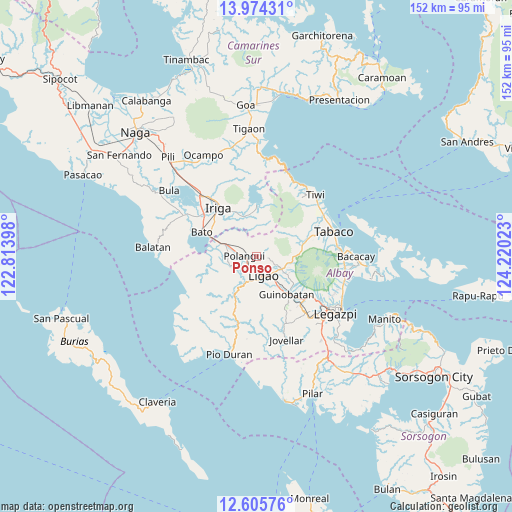
Ponso GPS coordinates[2]
13° 17' 27.6" North, 123° 31' 1.56" East
| Map corner | latitude | longitude |
|---|---|---|
| Upper-left | 13.97431°, | 122.81398° |
| Center: | 13.291°, | 123.5171° |
| Lower-right: | 12.60576°, | 124.22023° |
| Map W x H: | 152.2×152.2 km | = 94.6×94.6mi |
| max Lat: | 20.78733° ⇑40.1% North |
| Ponso: | 13.291° |
| min Lat: | ⇓59.9% South 4.65442° |
| min Long | Ponso | max Long |
| 117.04868° | 123.5171° | 126.58417° |
| W 62.6%⇐ | ⇒37.4% E |
Elevation
Elevation of Ponso is 42 m = 138 ft, and this is 45.9 m = 151 ft below average elevation for this country.
| Max E: |
2262 m = 7421 ft | 34.8% |
| Avg. | 87.9 m = 288 ft | |
| Ponso | 42 m = 138 ft | |
Min E: |
-2 m = -7 ft | 65.2% |
See also: Philippines elevation on elevation.city.
Geographical zone
Ponso is located in North Torrid zone (between Equator and Tropic of Cancer). Distance of this Northern Tropic circle is 1128.1 km =701 mi to North.| Distance of | km | miles | from Ponso |
|---|---|---|---|
| North Pole | 8529.2 | 5299.8 | to North |
| Arctic Circle | 5923.4 | 3680.6 | to North |
| Tropic Cancer | 1128.1 | 701 | to North |
| Equator | 1477.8 | 918.3 | to South |


Nearby cities:
15 places around Ponso: (largest is in red/bold)
• Balinad
3.1 km =1.9 mi,  86°
86°
• Balogo
3.5 km =2.2 mi,  97°
97°
• Batana
6.8 km =4.2 mi,  132°
132°
• City of Ligao
8.3 km =5.2 mi,  182°
182°
• Herrera
6.9 km =4.3 mi,  110°
110°
• Iraya
4.6 km =2.9 mi, 180°
• Lanigay
3.4 km =2.1 mi,  327°
327°
• Libon
8.5 km =5.3 mi,  276°
276°
• Ligao
8.2 km =5.1 mi, 178°
• Mahaba
4.5 km =2.8 mi, 125°
• Manga
6.3 km =3.9 mi,  250°
250°
• Polangui
3.4 km =2.1 mi,  272°
272°
• San Jose
7.5 km =4.7 mi,  28°
28°
• Tinampo
7.1 km =4.4 mi,  188°
188°
• Tuburan
6.7 km =4.2 mi,  145°
145°
Sources, notices
• [Note1] Compared only with cities in Philippines existing in our database
• [Src1] Map data: © OpenStreetMap contributors (CC-BY-SA)
• [Src2] Other city data from geonames.org with taken over terms of usage.
• [Src3] Geographical zone / Annual Mean Temperature by Robert A. Rohde @ Wikipedia
