Balinad geodata
Balinad (Bicol) is a populated place; located in Philippines in Asia/Manila (GMT+8) time zone. With population of 3,032 people, there are 2492 cities with bigger population in this country. Compared to other cities in Philippines, 59.9% of cities are located further ↓South; 63% of cities are located further ←West and 71.2% of cities have lower elevation than Balinad. Note1


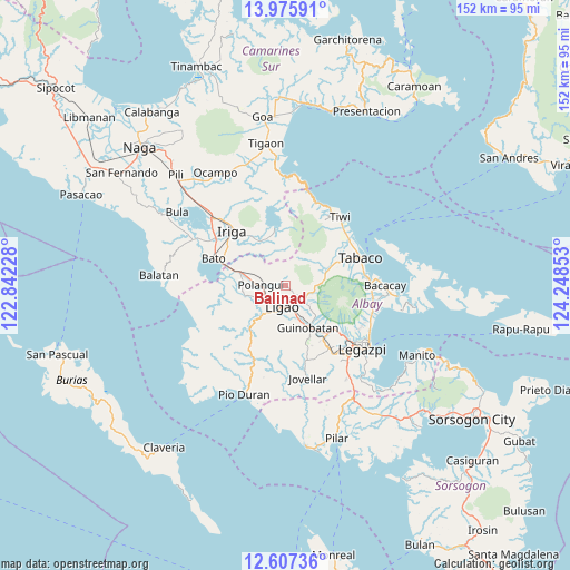
Balinad GPS coordinates[2]
13° 17' 33.36" North, 123° 32' 43.44" East
| Map corner | latitude | longitude |
|---|---|---|
| Upper-left | 13.97591°, | 122.84228° |
| Center: | 13.2926°, | 123.5454° |
| Lower-right: | 12.60736°, | 124.24853° |
| Map W x H: | 152.2×152.2 km | = 94.6×94.6mi |
| max Lat: | 20.78733° ⇑40.1% North |
| Balinad: | 13.2926° |
| min Lat: | ⇓59.9% South 4.65442° |
| min Long | Balinad | max Long |
| 117.04868° | 123.5454° | 126.58417° |
| W 63%⇐ | ⇒37% E |
Elevation
Elevation of Balinad is 55 m = 180 ft, and this is 32.9 m = 108 ft below average elevation for this country.
| Max E: |
2262 m = 7421 ft | 28.8% |
| Avg. | 87.9 m = 288 ft | |
| Balinad | 55 m = 180 ft | |
Min E: |
-2 m = -7 ft | 71.2% |
See also: Philippines elevation on elevation.city.
Geographical zone
Balinad is located in North Torrid zone (between Equator and Tropic of Cancer). Distance of this Northern Tropic circle is 1127.9 km =700.8 mi to North.| Distance of | km | miles | from Balinad |
|---|---|---|---|
| North Pole | 8529.1 | 5299.7 | to North |
| Arctic Circle | 5923.2 | 3680.5 | to North |
| Tropic Cancer | 1127.9 | 700.8 | to North |
| Equator | 1478 | 918.4 | to South |


Nearby cities:
15 places around Balinad: (largest is in red/bold)
• Balogo
0.8 km =0.5 mi,  143°
143°
• Batana
5.2 km =3.2 mi,  156°
156°
• Bonga
8.5 km =5.3 mi,  176°
176°
• City of Ligao
9.1 km =5.7 mi,  201°
201°
• Herrera
4.3 km =2.7 mi,  127°
127°
• Iraya
5.7 km =3.5 mi,  213°
213°
• Lanigay
5.6 km =3.5 mi,  298°
298°
• Ligao
8.9 km =5.5 mi, 198°
• Mahaba
2.9 km =1.8 mi,  166°
166°
• Muladbucad
8.8 km =5.5 mi, 132°
• Polangui
6.5 km =4 mi,  269°
269°
• Ponso
3.1 km =1.9 mi, 266°
• San Jose
6.4 km =4 mi,  4°
4°
• Tinampo
8.3 km =5.2 mi, 209°
• Tuburan
5.7 km =3.5 mi, 172°
Sources, notices
• [Note1] Compared only with cities in Philippines existing in our database
• [Src1] Map data: © OpenStreetMap contributors (CC-BY-SA)
• [Src2] Other city data from geonames.org with taken over terms of usage.
• [Src3] Geographical zone / Annual Mean Temperature by Robert A. Rohde @ Wikipedia
