Mahaba geodata
Mahaba (Bicol) is a populated place; located in Philippines in Asia/Manila (GMT+8) time zone. With population of 3,125 people, there are 2388 cities with bigger population in this country. Compared to other cities in Philippines, 59.6% of cities are located further ↓South; 63.2% of cities are located further ←West and 73.4% of cities have lower elevation than Mahaba. Note1


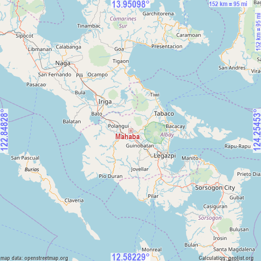
Mahaba GPS coordinates[2]
13° 16' 3.36" North, 123° 33' 5.04" East
| Map corner | latitude | longitude |
|---|---|---|
| Upper-left | 13.95098°, | 122.84828° |
| Center: | 13.2676°, | 123.5514° |
| Lower-right: | 12.58229°, | 124.25453° |
| Map W x H: | 152.2×152.2 km | = 94.6×94.6mi |
| max Lat: | 20.78733° ⇑40.4% North |
| Mahaba: | 13.2676° |
| min Lat: | ⇓59.6% South 4.65442° |
| min Long | Mahaba | max Long |
| 117.04868° | 123.5514° | 126.58417° |
| W 63.2%⇐ | ⇒36.8% E |
Elevation
Elevation of Mahaba is 62 m = 203 ft, and this is 25.9 m = 85 ft below average elevation for this country.
| Max E: |
2262 m = 7421 ft | 26.6% |
| Avg. | 87.9 m = 288 ft | |
| Mahaba | 62 m = 203 ft | |
Min E: |
-2 m = -7 ft | 73.4% |
See also: Philippines elevation on elevation.city.
Geographical zone
Mahaba is located in North Torrid zone (between Equator and Tropic of Cancer). Distance of this Northern Tropic circle is 1130.7 km =702.6 mi to North.| Distance of | km | miles | from Mahaba |
|---|---|---|---|
| North Pole | 8531.8 | 5301.4 | to North |
| Arctic Circle | 5926 | 3682.2 | to North |
| Tropic Cancer | 1130.7 | 702.6 | to North |
| Equator | 1475.2 | 916.6 | to South |


Nearby cities:
15 places around Mahaba: (largest is in red/bold)
• Balinad
2.9 km =1.8 mi,  346°
346°
• Balogo
2.2 km =1.4 mi, 354°
• Batana
2.4 km =1.5 mi,  145°
145°
• Bonga
5.7 km =3.5 mi,  181°
181°
• City of Ligao
6.9 km =4.3 mi,  215°
215°
• Herrera
2.8 km =1.7 mi,  86°
86°
• Iraya
4.2 km =2.6 mi,  242°
242°
• Lanigay
7.8 km =4.8 mi,  314°
314°
• Ligao
6.6 km =4.1 mi,  211°
211°
• Muladbucad
6.7 km =4.2 mi,  118°
118°
• Polangui
7.6 km =4.7 mi,  291°
291°
• Ponso
4.5 km =2.8 mi, 305°
• San Rafael
7.7 km =4.8 mi,  137°
137°
• Tinampo
6.5 km =4 mi,  227°
227°
• Tuburan
2.9 km =1.8 mi, 178°
Sources, notices
• [Note1] Compared only with cities in Philippines existing in our database
• [Src1] Map data: © OpenStreetMap contributors (CC-BY-SA)
• [Src2] Other city data from geonames.org with taken over terms of usage.
• [Src3] Geographical zone / Annual Mean Temperature by Robert A. Rohde @ Wikipedia
