Ligao geodata
Ligao (Bicol) is a seat of a third-order administrative division; located in Philippines in Asia/Manila (GMT+8) time zone. With population of 10,295 people, there are 594 cities with bigger population in this country. Compared to other cities in Philippines, 59% of cities are located further ↓South; 62.6% of cities are located further ←West and 72.8% of cities have lower elevation than Ligao. Note1


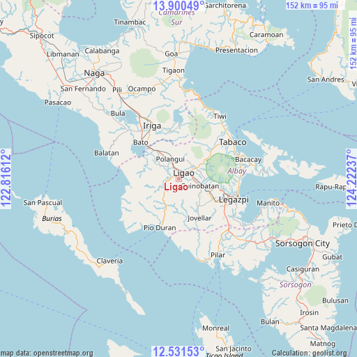
Ligao GPS coordinates[2]
13° 13' 1.092" North, 123° 31' 9.264" East
| Map corner | latitude | longitude |
|---|---|---|
| Upper-left | 13.90049°, | 122.81612° |
| Center: | 13.21697°, | 123.51924° |
| Lower-right: | 12.53153°, | 124.22237° |
| Map W x H: | 152.2×152.2 km | = 94.6×94.6mi |
| max Lat: | 20.78733° ⇑41% North |
| Ligao: | 13.21697° |
| min Lat: | ⇓59% South 4.65442° |
| min Long | Ligao | max Long |
| 117.04868° | 123.51924° | 126.58417° |
| W 62.6%⇐ | ⇒37.4% E |
Elevation
Elevation of Ligao is 60 m = 197 ft, and this is 27.9 m = 92 ft below average elevation for this country.
| Max E: |
2262 m = 7421 ft | 27.2% |
| Avg. | 87.9 m = 288 ft | |
| Ligao | 60 m = 197 ft | |
Min E: |
-2 m = -7 ft | 72.8% |
See also: Philippines elevation on elevation.city.
Geographical zone
Ligao is located in North Torrid zone (between Equator and Tropic of Cancer). Distance of this Northern Tropic circle is 1136.3 km =706.1 mi to North.| Distance of | km | miles | from Ligao |
|---|---|---|---|
| North Pole | 8537.5 | 5305 | to North |
| Arctic Circle | 5931.6 | 3685.7 | to North |
| Tropic Cancer | 1136.3 | 706.1 | to North |
| Equator | 1469.6 | 913.2 | to South |


Nearby cities:
15 places around Ligao: (largest is in red/bold)
• Balinad
8.9 km =5.5 mi,  18°
18°
• Balogo
8.5 km =5.3 mi, 22°
• Batana
6.1 km =3.8 mi,  53°
53°
• Bonga
3.3 km =2.1 mi,  90°
90°
• City of Ligao
0.5 km =0.3 mi,  268°
268°
• Guinobatan
9.1 km =5.7 mi,  108°
108°
• Herrera
8.5 km =5.3 mi, 47°
• Iraya
3.7 km =2.3 mi,  355°
355°
• Mahaba
6.6 km =4.1 mi,  31°
31°
• Manga
8.7 km =5.4 mi,  314°
314°
• Paulba
7.5 km =4.7 mi,  235°
235°
• Ponso
8.2 km =5.1 mi, 358°
• San Rafael
8.7 km =5.4 mi, 90°
• Tinampo
1.8 km =1.1 mi, 313°
• Tuburan
4.5 km =2.8 mi, 52°
Sources, notices
• [Note1] Compared only with cities in Philippines existing in our database
• [Src1] Map data: © OpenStreetMap contributors (CC-BY-SA)
• [Src2] Other city data from geonames.org with taken over terms of usage.
• [Src3] Geographical zone / Annual Mean Temperature by Robert A. Rohde @ Wikipedia
