Culasi geodata
Culasi (Western Visayas) is a populated place; located in Philippines in Asia/Manila (GMT+8) time zone. With population of 4,123 people, there are 1654 cities with bigger population in this country. Compared to other cities in Philippines, 56% of cities are located further ↑North; 52.9% of cities are located further ←West and 95.5% of cities have higher elevation than Culasi. Note1


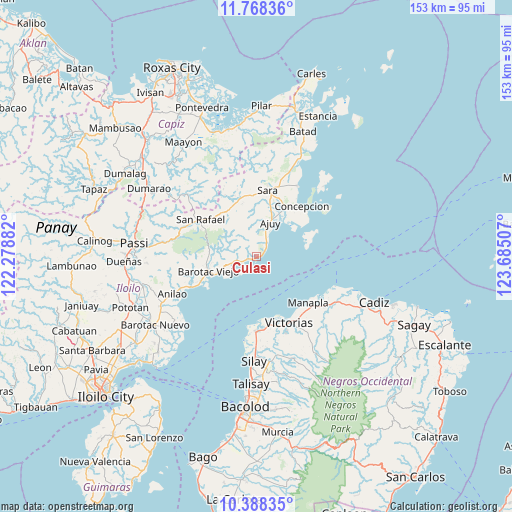
Culasi GPS coordinates[2]
11° 4' 45.012" North, 122° 58' 54.984" East
| Map corner | latitude | longitude |
|---|---|---|
| Upper-left | 11.76836°, | 122.27882° |
| Center: | 11.07917°, | 122.98194° |
| Lower-right: | 10.38835°, | 123.68507° |
| Map W x H: | 153.4×153.4 km | = 95.3×95.3mi |
| max Lat: | 20.78733° ⇑56% North |
| Culasi: | 11.07917° |
| min Lat: | ⇓44% South 4.65442° |
| min Long | Culasi | max Long |
| 117.04868° | 122.98194° | 126.58417° |
| W 52.9%⇐ | ⇒47.1% E |
Elevation
Elevation of Culasi is 5 m = 16 ft, and this is 82.9 m = 272 ft below average elevation for this country.
| Max E: |
2262 m = 7421 ft | 95.5% |
| Avg. | 87.9 m = 288 ft | |
| Culasi | 5 m = 16 ft | |
Min E: |
-2 m = -7 ft | 4.5% |
See also: Philippines elevation on elevation.city.
Geographical zone
Culasi is located in North Torrid zone (between Equator and Tropic of Cancer). Distance of Equator is 1231.9 km =765.5 mi to South.| Distance of | km | miles | from Culasi |
|---|---|---|---|
| North Pole | 8775.2 | 5452.7 | to North |
| Arctic Circle | 6169.3 | 3833.4 | to North |
| Tropic Cancer | 1374 | 853.8 | to North |
| Equator | 1231.9 | 765.5 | to South |


Nearby cities:
15 places around Culasi: (largest is in red/bold)
• Ajuy
11.2 km =7 mi,  21°
21°
• Anoring
19.8 km =12.3 mi, 16°
• Banate
19.9 km =12.4 mi,  244°
244°
• Barotac Viejo
14.7 km =9.1 mi,  253°
253°
• Bay-ang
6.6 km =4.1 mi,  221°
221°
• Carmelo
19.3 km =12 mi, 248°
• Lemery
17.4 km =10.8 mi,  339°
339°
• Madalag
20 km =12.4 mi,  179°
179°
• Malayo-an
3.6 km =2.2 mi,  54°
54°
• Pili
5.7 km =3.5 mi,  38°
38°
• San Rafael
20.1 km =12.5 mi,  303°
303°
• San Salvador
18.1 km =11.2 mi, 242°
• Santiago
8 km =5 mi, 252°
• Talokgañgan
16.9 km =10.5 mi, 242°
• Tortosa
20.1 km =12.5 mi,  144°
144°
Sources, notices
• [Note1] Compared only with cities in Philippines existing in our database
• [Src1] Map data: © OpenStreetMap contributors (CC-BY-SA)
• [Src2] Other city data from geonames.org with taken over terms of usage.
• [Src3] Geographical zone / Annual Mean Temperature by Robert A. Rohde @ Wikipedia
