Ajuy geodata
Ajuy (Western Visayas) is a seat of a third-order administrative division; located in Philippines in Asia/Manila (GMT+8) time zone. With population of 8,695 people, there are 711 cities with bigger population in this country. Compared to other cities in Philippines, 54.9% of cities are located further ↑North; 53.6% of cities are located further ←West and 80.7% of cities have higher elevation than Ajuy. Note1


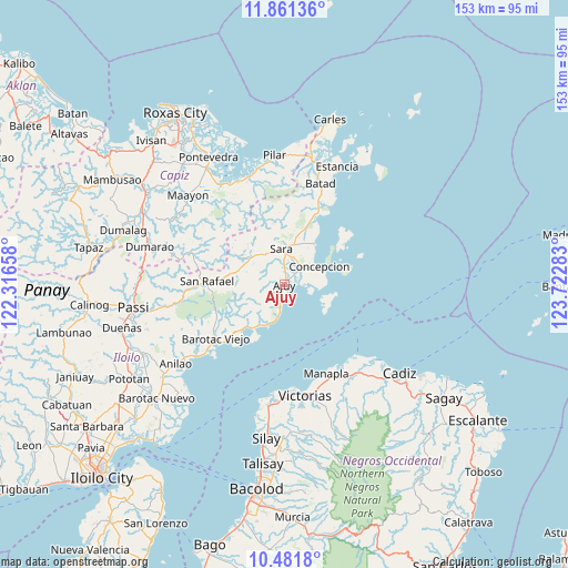
Ajuy GPS coordinates[2]
11° 10' 20.64" North, 123° 1' 10.92" East
| Map corner | latitude | longitude |
|---|---|---|
| Upper-left | 11.86136°, | 122.31658° |
| Center: | 11.1724°, | 123.0197° |
| Lower-right: | 10.4818°, | 123.72283° |
| Map W x H: | 153.4×153.4 km | = 95.3×95.3mi |
| max Lat: | 20.78733° ⇑54.9% North |
| Ajuy: | 11.1724° |
| min Lat: | ⇓45.1% South 4.65442° |
| min Long | Ajuy | max Long |
| 117.04868° | 123.0197° | 126.58417° |
| W 53.6%⇐ | ⇒46.4% E |
Elevation
Elevation of Ajuy is 9 m = 30 ft, and this is 78.9 m = 259 ft below average elevation for this country.
| Max E: |
2262 m = 7421 ft | 80.7% |
| Avg. | 87.9 m = 288 ft | |
| Ajuy | 9 m = 30 ft | |
Min E: |
-2 m = -7 ft | 19.3% |
See also: Philippines elevation on elevation.city.
Geographical zone
Ajuy is located in North Torrid zone (between Equator and Tropic of Cancer). Distance of Equator is 1242.3 km =771.9 mi to South.| Distance of | km | miles | from Ajuy |
|---|---|---|---|
| North Pole | 8764.8 | 5446.2 | to North |
| Arctic Circle | 6158.9 | 3827 | to North |
| Tropic Cancer | 1363.7 | 847.4 | to North |
| Equator | 1242.3 | 771.9 | to South |


Nearby cities:
15 places around Ajuy: (largest is in red/bold)
• Anoring
8.8 km =5.5 mi,  9°
9°
• Bay-ang
17.5 km =10.9 mi,  209°
209°
• Concepcion
10.7 km =6.6 mi,  63°
63°
• Culasi
11.2 km =7 mi,  201°
201°
• Igbon
16.6 km =10.3 mi,  73°
73°
• Lemery
11.7 km =7.3 mi,  300°
300°
• Malayo-an
8.4 km =5.2 mi,  187°
187°
• Pili
5.9 km =3.7 mi, 185°
• Platagata
20.8 km =12.9 mi,  45°
45°
• Polopina
16.4 km =10.2 mi,  76°
76°
• Quipot
12.5 km =7.8 mi,  350°
350°
• San Dionisio
13.8 km =8.6 mi,  37°
37°
• Santiago
17.3 km =10.7 mi,  222°
222°
• Sara
9.5 km =5.9 mi,  356°
356°
• Tambalisa
19.2 km =11.9 mi, 55°
Sources, notices
• [Note1] Compared only with cities in Philippines existing in our database
• [Src1] Map data: © OpenStreetMap contributors (CC-BY-SA)
• [Src2] Other city data from geonames.org with taken over terms of usage.
• [Src3] Geographical zone / Annual Mean Temperature by Robert A. Rohde @ Wikipedia
