Mahayag geodata
Mahayag (Central Visayas) is a populated place; located in Philippines in Asia/Manila (GMT+8) time zone. With population of 2,353 people, there are 3555 cities with bigger population in this country. Compared to other cities in Philippines, 69% of cities are located further ↑North; 75.9% of cities are located further ←West and 83.5% of cities have lower elevation than Mahayag. Note1


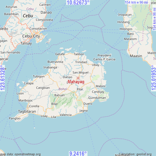
Mahayag GPS coordinates[2]
9° 56' 5.64" North, 124° 18' 59.04" East
| Map corner | latitude | longitude |
|---|---|---|
| Upper-left | 10.62673°, | 123.61328° |
| Center: | 9.9349°, | 124.3164° |
| Lower-right: | 9.2416°, | 125.01953° |
| Map W x H: | 154×154 km | = 95.7×95.7mi |
| max Lat: | 20.78733° ⇑69% North |
| Mahayag: | 9.9349° |
| min Lat: | ⇓31% South 4.65442° |
| min Long | Mahayag | max Long |
| 117.04868° | 124.3164° | 126.58417° |
| W 75.9%⇐ | ⇒24.1% E |
Elevation
Elevation of Mahayag is 121 m = 397 ft, and this is 33.1 m = 109 ft above average elevation for this country.
| Max E: |
2262 m = 7421 ft | 16.5% |
| Mahayag | 121 m 397 ft | |
| Avg. | 87.9 m = 288 ft | |
Min E: |
-2 m = -7 ft | 83.5% |
See also: Philippines elevation on elevation.city.
Geographical zone
Mahayag is located in North Torrid zone (between Equator and Tropic of Cancer). Distance of Equator is 1104.7 km =686.4 mi to South.| Distance of | km | miles | from Mahayag |
|---|---|---|---|
| North Pole | 8902.4 | 5531.7 | to North |
| Arctic Circle | 6296.5 | 3912.5 | to North |
| Tropic Cancer | 1501.3 | 932.9 | to North |
| Equator | 1104.7 | 686.4 | to South |


Nearby cities:
15 places around Mahayag: (largest is in red/bold)
• Alicia
14.5 km =9 mi,  107°
107°
• Buenavista
14.7 km =9.1 mi,  224°
224°
• Bugsoc
17.6 km =10.9 mi,  196°
196°
• Dagohoy
5.3 km =3.3 mi, 223°
• Danao
10.3 km =6.4 mi,  276°
276°
• Hinlayagan Ilaud
10.8 km =6.7 mi,  10°
10°
• La Hacienda
10.2 km =6.3 mi,  125°
125°
• Pilar
11.8 km =7.3 mi,  174°
174°
• San Miguel
5.6 km =3.5 mi, 168°
• San Miguel
6.4 km =4 mi,  25°
25°
• San Pascual
12.5 km =7.8 mi,  80°
80°
• San Roque
17.5 km =10.9 mi,  2°
2°
• Sierra Bullones
14.3 km =8.9 mi,  190°
190°
• Tagum Norte
17.5 km =10.9 mi, 27°
• Trinidad
16.3 km =10.1 mi, 10°
Sources, notices
• [Note1] Compared only with cities in Philippines existing in our database
• [Src1] Map data: © OpenStreetMap contributors (CC-BY-SA)
• [Src2] Other city data from geonames.org with taken over terms of usage.
• [Src3] Geographical zone / Annual Mean Temperature by Robert A. Rohde @ Wikipedia
