San Miguel geodata
San Miguel (Central Visayas) is a populated place; located in Philippines in Asia/Manila (GMT+8) time zone. With population of 2,414 people, there are 3439 cities with bigger population in this country. Compared to other cities in Philippines, 69.5% of cities are located further ↑North; 76.1% of cities are located further ←West and 84.4% of cities have lower elevation than San Miguel. Note1


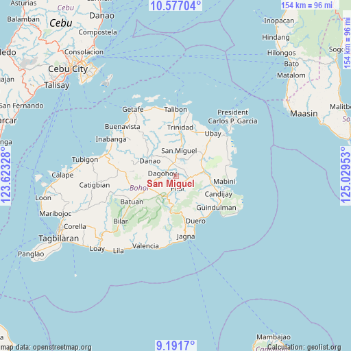
San Miguel GPS coordinates[2]
9° 53' 6.36" North, 124° 19' 35.04" East
| Map corner | latitude | longitude |
|---|---|---|
| Upper-left | 10.57704°, | 123.62328° |
| Center: | 9.8851°, | 124.3264° |
| Lower-right: | 9.1917°, | 125.02953° |
| Map W x H: | 154×154 km | = 95.7×95.7mi |
| max Lat: | 20.78733° ⇑69.5% North |
| San Miguel: | 9.8851° |
| min Lat: | ⇓30.5% South 4.65442° |
| min Long | San Miguel | max Long |
| 117.04868° | 124.3264° | 126.58417° |
| W 76.1%⇐ | ⇒23.9% E |
Elevation
Elevation of San Miguel is 127 m = 417 ft, and this is 39.1 m = 128 ft above average elevation for this country.
| Max E: |
2262 m = 7421 ft | 15.6% |
| San Miguel | 127 m 417 ft | |
| Avg. | 87.9 m = 288 ft | |
Min E: |
-2 m = -7 ft | 84.4% |
See also: Philippines elevation on elevation.city.
Geographical zone
San Miguel is located in North Torrid zone (between Equator and Tropic of Cancer). Distance of Equator is 1099.1 km =682.9 mi to South.| Distance of | km | miles | from San Miguel |
|---|---|---|---|
| North Pole | 8907.9 | 5535.1 | to North |
| Arctic Circle | 6302.1 | 3915.9 | to North |
| Tropic Cancer | 1506.8 | 936.3 | to North |
| Equator | 1099.1 | 682.9 | to South |


Nearby cities:
15 places around San Miguel: (largest is in red/bold)
• Alicia
12.7 km =7.9 mi,  85°
85°
• Buenavista
12.4 km =7.7 mi,  246°
246°
• Bugsoc
12.8 km =8 mi,  208°
208°
• Dagohoy
5 km =3.1 mi,  289°
289°
• Danao
13.1 km =8.1 mi,  300°
300°
• La Hacienda
7.2 km =4.5 mi, 93°
• Lombog
15.5 km =9.6 mi,  139°
139°
• Mahayag
5.6 km =3.5 mi,  348°
348°
• Mayana
14.6 km =9.1 mi,  168°
168°
• Pilar
6.2 km =3.9 mi,  179°
179°
• San Isidro
15 km =9.3 mi, 212°
• San Miguel
11.4 km =7.1 mi,  8°
8°
• San Pascual
13.6 km =8.5 mi,  55°
55°
• Sierra Bullones
9.3 km =5.8 mi,  203°
203°
• Valle Hermoso
14.1 km =8.8 mi,  224°
224°
Sources, notices
• [Note1] Compared only with cities in Philippines existing in our database
• [Src1] Map data: © OpenStreetMap contributors (CC-BY-SA)
• [Src2] Other city data from geonames.org with taken over terms of usage.
• [Src3] Geographical zone / Annual Mean Temperature by Robert A. Rohde @ Wikipedia
