Buenavista geodata
Buenavista (Central Visayas) is a populated place; located in Philippines in Asia/Manila (GMT+8) time zone. With population of 2,454 people, there are 3376 cities with bigger population in this country. Compared to other cities in Philippines, 69.9% of cities are located further ↑North; 74.2% of cities are located further ←West and 89.7% of cities have lower elevation than Buenavista. Note1


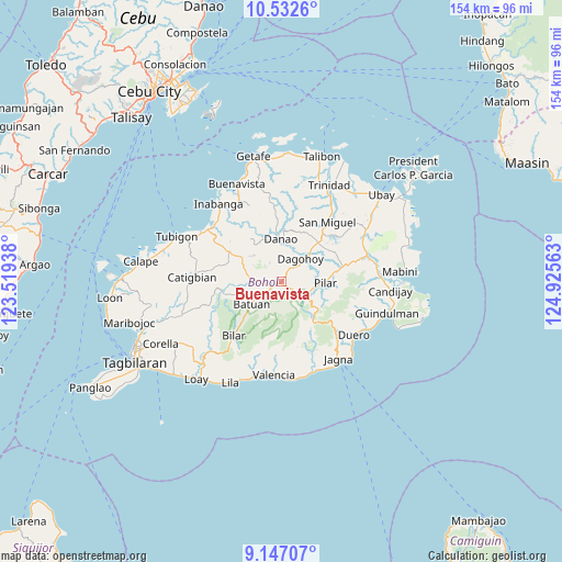
Buenavista GPS coordinates[2]
9° 50' 26.016" North, 124° 13' 21" East
| Map corner | latitude | longitude |
|---|---|---|
| Upper-left | 10.5326°, | 123.51938° |
| Center: | 9.84056°, | 124.2225° |
| Lower-right: | 9.14707°, | 124.92563° |
| Map W x H: | 154.1×154.1 km | = 95.8×95.8mi |
| max Lat: | 20.78733° ⇑69.9% North |
| Buenavista: | 9.84056° |
| min Lat: | ⇓30.1% South 4.65442° |
| min Long | Buenavista | max Long |
| 117.04868° | 124.2225° | 126.58417° |
| W 74.2%⇐ | ⇒25.8% E |
Elevation
Elevation of Buenavista is 222 m = 728 ft, and this is 134.1 m = 440 ft above average elevation for this country.
| Max E: |
2262 m = 7421 ft | 10.3% |
| Buenavista | 222 m 728 ft | |
| Avg. | 87.9 m = 288 ft | |
Min E: |
-2 m = -7 ft | 89.7% |
See also: Philippines elevation on elevation.city.
Geographical zone
Buenavista is located in North Torrid zone (between Equator and Tropic of Cancer). Distance of Equator is 1094.2 km =679.9 mi to South.| Distance of | km | miles | from Buenavista |
|---|---|---|---|
| North Pole | 8912.9 | 5538.2 | to North |
| Arctic Circle | 6307 | 3919 | to North |
| Tropic Cancer | 1511.8 | 939.4 | to North |
| Equator | 1094.2 | 679.9 | to South |


Nearby cities:
15 places around Buenavista: (largest is in red/bold)
• Batuan
10.5 km =6.5 mi,  230°
230°
• Bugsoc
8.3 km =5.2 mi,  139°
139°
• Carmen
3.5 km =2.2 mi, 234°
• Dagohoy
9.4 km =5.8 mi,  45°
45°
• Danao
11.6 km =7.2 mi,  0°
0°
• Mahayag
14.7 km =9.1 mi,  44°
44°
• Mayana
17 km =10.6 mi,  123°
123°
• Nueva Fuerza
6.1 km =3.8 mi,  276°
276°
• Nueva Vida Sur
8.1 km =5 mi,  220°
220°
• Pilar
11.6 km =7.2 mi,  96°
96°
• Sagbayan
16.5 km =10.3 mi,  299°
299°
• San Isidro
8.4 km =5.2 mi,  156°
156°
• San Miguel
12.4 km =7.7 mi,  66°
66°
• Sierra Bullones
8.4 km =5.2 mi, 115°
• Valle Hermoso
5.4 km =3.4 mi, 163°
Sources, notices
• [Note1] Compared only with cities in Philippines existing in our database
• [Src1] Map data: © OpenStreetMap contributors (CC-BY-SA)
• [Src2] Other city data from geonames.org with taken over terms of usage.
• [Src3] Geographical zone / Annual Mean Temperature by Robert A. Rohde @ Wikipedia
